 Route Editor

| Guide | ♦ | 68 Triplogs | 2 Topics |
details | drive | no permit | forecast | 🔥 route |
stats |
photos | triplogs | topics | location |
| 597 | 68 | 2 |
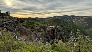
Calibrate your internal compass by chumley   Overview OverviewNorth Peak Trail #24 is one of three trails that climb to the higher elevations of the northern reaches of the Mazatzal Mountains. (Mazatzal Divide #23 and Bull Spring #34 - being the other two). This trail is MUCH steeper than the other two, climbing quickly from near 4000 to over 6000 feet in about 2.5 miles. Hike The hike begins along an old eroded two-track that parallels the Mineral Creek drainage at a mild grade for 3/4ths of a mile before turning south toward Mineral Spring. This area features some shade trees and seasonal surface water that flows as the trail crosses the drainage two times. From the spring area, the trail grade increases significantly climbing 1300 feet in the next mile following a steep ridge and crosses the Mazatzal Wilderness boundary along the way.
As the trail traverses the northwestern slope of North Peak (an off-trail summit option exists: North Peak 2449) open views reveal the expansive high-country of the northern Mazatzal Mountains with views far beyond. Two prominent patches of unburned forest with mature ponderosa pines appear in two basins east of you. The northern patch is in a basin that feeds the headwaters of City Creek, and a mile or so south is the terminus of this trail in an area known as The Park. As the trail cuts toward The Park, it drops about 200 feet over half a mile -- a welcome respite from the unrelenting climb thusfar -- before making a pass through a small drainage and regaining most of that elevation on the other side. The last half mile drops 200 feet before reaching the junction with the Mazatzal Divide Trail just north of The Park. From here you can make a loop with the Divide or AZT back north, or head south with multiple other multiday backpacking options across this vast wilderness. Backpacking and Water Sources There are few camping options along this trail until reaching at least the 6000-foot contour and really no enjoyable options until reaching the Divide Trail. A couple of dry camps might be possible but feature no water and might be windy and exposed, but also feature scenic views. There are no reliable water sources along the trail between Mineral Spring and the Divide Trail. Backpackers and/or AZT thru-hikers occasionally make camp at The Park not far south of the junction where this trail terminates at the Divide Trail. Seasonal water may be found a quarter mile south of The Park on the Divide Trail at the Wet Bottom Creek drainage, but should not be considered reliable. Check out the Official Route and Triplogs. Leave No Trace and +Add a Triplog after your hike to support this local community. One-Way Notice This hike is listed as One-Way. When hiking several trails on a single "hike", log it with a generic name that describes the hike. Then link the trails traveled, check out the example. | |||||||||||||||||||||||||||||||||||||||||||||||||||||||||||||||||||||||||||||||||||||||||||||||||||||||||||||||||||||||||||||||||||||||||||||||||||||||||||||||||||||||||||||||||||||||||||||||||||||||||||||||||||||


