Route Editor

| Guide | ♦ | 18 Triplogs | 1 Topic |
details | drive | permit | forecast | map |
stats |
photos | triplogs | topic | location |
| 213 | 18 | 1 |
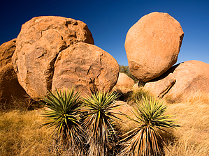
Learn some history at the Dragoons by JoelHazelton   Overview OverviewThe Dragoon Mountains are mainly known for the famed Chiricahua Apache Warrior, Cochise, and his stronghold. What many people don't realize, however, is that there is evidence of humans hundreds and hundreds of years older than the Apaches hidden in these mountains. The most easily accessible of these is Council Rocks. History It is thought that the pictographs scattered around Council Rocks were put there by ancient Mogollon people roughly 1,000 years ago, along with the grinding mortars used for grinding nuts and seeds.
Hike From the parking area, you will have a few options to reach Council Rocks. The house-sized boulders directly above are your destination. There is no official "trail" to get there; rather, a few paths that lead straight up. We chose a break in the fence on the left side of the parking lot with a path that looked well-traveled. It meandered around the base of the rocks for a minute and then shot straight up. Catclaw was prevalent and required a bit of dodging. The path topped out at a large room created by a giant fallen boulder. There was evidence of a campfire, but no trash. On the other side of the large room is a wall full of pictographs. If you have a hard time spotting them (which some people do), just find the free-standing sign describing the pictographs and then look about 20 feet in front of it. They are a faint pinkish color, although much better preserved and less faded than other known pictographs. Make sure to do plenty of exploring in this area. There is a different view around every corner and the boulders are fun to climb on. Beyond the immediate Council Rocks area, there is a well-worn path that continues north. It is worn for about 0.5 miles before petering out into a series of fainter paths and washes. There seems to be plenty of potential exploring in this area. Conclusion We did this hike as part of a relaxing New Year's camping trip and were surprised at the number of people visiting the western Dragoons. All of the info I've been able to find on the west side of the range included phrases like "remote" and "lesser-known". Don't believe what you hear elsewhere; people ARE visiting the Western Dragoons. There are a plethora of top-notch car camping spots on the back-roads, but they were just about all taken when we were there. During our 1.5 hour exploration of the Council Rock area, we passed at least 3 other groups. I can't blame any of them, though. The Dragoons are beautiful, and the west side is the best side for enjoying the sunsets, as the sun illuminates the west face of the mountain and turns the boulders bright orange. If you decide to visit Council Rocks, consider checking out one of the other nearby hikes, such as Stronghold Canyon West or Slavin Gulch. It will be hot in the summer, so bring plenty of water during those warmer months. Lastly, the road to the trailhead, 687k, is not suitable for a low clearance vehicle. If you have low or medium clearance, park in one of the pullouts near the 687K turnoff and walk to the trailhead. Check out the Triplogs. Leave No Trace and +Add a Triplog after your hike to support this local community. | |||||||||||||||||||||||||||||||||||||||||||||||||||||||||||||||||||||||||||||||||||||||||||||