Route Editor

| Guide | ♦ | 5 Triplogs | 0 Topics |
details | drive | no permit | forecast | route |
stats |
photos | triplogs | topics | location |
| 5 | 5 | 0 |
Canyons are inherently risky. Flash floods occur without notice on sunny days. Technical skills & surrounding topography knowledge required yet does not eliminate risk.
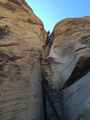
 An interesting canyon on the Red Rock escarpment with rappels down walls and fluted dryfalls, downclimbs of boulder chokes and slickrock, and some bushwhacking to keep things interesting. Warning Be smart! Although this is a relatively frequently-visited canyon, always be prepared with enough gear to replace webbing and rings in case they are worn or missing. At minimum, you will need: helmet, harness, rappelling device and biner, and 2x100 ft ropes. Bolts are not allowed here and some natural anchor locations in this canyon present a potential for the rope to get stuck - consider a partial trial pull before the last person descends, plus bring a way to ascend your rope and the skill to do so. As always, carry extra rope. The 6th and 7th rappels end in swimmer pools, so expect to need a wetsuit or extra clothing except in very warm weather or very low water conditions. Also make sure everyone in your group has practiced disconnecting from their rappelling device in deep water.
The rocks that line the parking pull-out block vehicle access to an old road that heads NNE up the slope - start hiking along this old road. Follow the road up to the ridge top, where it will turn abruptly east (right). Continue to follow the road until it drops down and turns north, then west to follow a drainage. Instead of turning north, continue up the ridge ahead and follow it east until you reach the top of the Red Rock escarpment and the clear use trail that runs north-south along it. Head north on the use trail for approx 600 ft, then turn east (right) onto the ridge that separates 2 forks of Mud Spring Canyon. Staying along this ridge, you can follow a use trail and drop into the canyon more gradually. You are aiming for the more northern (left) of the 2 forks of Mud Spring Canyon - by the time you reach the spot where the limestone scree meets slickrock, you should be in the drainage. Now is a good time to check your GPS and make sure you are in the right place before committing: 36.031415, -115.478948. After some bushwhacking and downclimbing over a boulder jam, you come to the first rappel. 90 ft (in 2 stages) down a vertical wall with nice desert varnish, anchored from a tree approx 10 feet up on a ledge RDC. Second rappel is just after the bottom of Rap 1 - approx 55 ft, anchored from a large rock near the top. Next comes a section of drops and potholes, which can be avoided via ledges LDC. After bypassing the drop/pothole section (or doing as a challenging downclimb), the 3rd rappel (100 ft in 3 stages) is anchored from a choke stone. The 4th rappel is just after the 3rd - 85 ft anchored from a boulder at the top. After this you're done rappelling for a bit, and get to spend some time rock-hopping and downclimbing. The worst of the bushwhacking in this section can be avoided by using a ledge LDC. Your next landmark is a large boulder wedged between the walls. Bypass RDC and come out into a more open section of canyon. This is an ideal spot to put on your wetsuit. Downclimb into a waist-deep pool (or bypass LDC) to get to the 5th rappel - dropping 50 ft under a choke stone boulder into a grotto-like space, anchored from one of many boulders at the top. A few pools, which you can swim or bypass (depending if you have your wetsuit), before the walls close in again to form a narrow water-sculpted chute. Anchored from a choke stone at the top of the chute, rappel 6 drops approx 20 ft into a swimmer. Rappel 7 is immediately after the end of this pool, approx 40 ft anchored on a small western redbud. Like rap 6, rappel 7 ends in a swimmer. After swimming out, it is possible to remain dry for the rest of the canyon, so change clothes here or remove your wet suit if you wish. Rappel 8, approx 60 ft anchored from one of the trees at the top, is shortly after the last pool deep enough to slide into if full (or pool can be bypassed). All that remains now is some boulder-hopping and bushwhacking, then open desert wash hiking to your shuttle vehicle (approx 1.5 mi total). Follow the wash, coming out of the main channel LDC when possible to avoid the worst bushwhacking. If you hit the Black Velvet Trail (a climber use trail), turn south (right) and follow it to the road, then hike ENE along the road to your vehicle. If you don't see the trail, don't worry, you will soon see your vehicle up on the road just south of the wash channel. Water Sources The water in the pools is usually pretty scummy. Bring your own water. Check out the Official Route and Triplogs. Leave No Trace and +Add a Triplog after your canyon trip to support this local community. | |||||||||||||||||||||||||||||||||||||||||||||||||||||||||||||||||||||||||||||||||||||||||||||||||