Route Editor

| Guide | ♦ | 13 Triplogs | 0 Topics |
details | drive | permit | forecast | route |
stats |
photos | triplogs | topics | location |
| 140 | 13 | 0 |
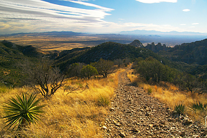
See Mexico from China! by PrestonSands   Overview OverviewThis hike follows old mining roads to the 7125-foot summit of China Peak, along the crest of the Dragoon Mountains. China Peak's spectacular 360-degree view of southern Arizona, coupled with the Dragoon's signature granite formations, makes for a great hike. As this hike makes use of Forest Road 697, which is a lightly used, high clearance four-wheel-drive road, one could shave several miles off of the hike if they are not opposed to scratching up their vehicle on thorny vegetation and rocks, on a road with limited turn around spots. This description begins at Middlemarch Road, which is the suggested starting point.
Zinc, lead, and silver was discovered in the Abrigo Limestone on the south slope of China Peak in 1913, leading to the development of the San Juan Mine (a.k.a. Gordon Mine). With over one thousand feet of underground tunnels, this operation supported a small mining camp nearby, known as Gordon Camp. Mining ceased in 1952, and the mines lie abandoned today. Hike From Middlemarch Road, the hike heads north, following the rocky route of Forest Road 697 up a small valley. Upon crossing a saddle at 1.1 miles, the road begins a steady ascent along a mountainside of ocotillo and grey limestone. Views from this area include Tombstone and the Mule and Huachuca ranges. The route comes tantalizingly close to impressive formations of Stronghold Granite before passing through a road cut into a hidden valley of oak-juniper woodland and lichen-encrusted cliffs. At the bottom of the valley, a side road leaves to the right: stay left. Our road continues north, following a rocky creek bed, and passes another side road to the right at 2.7 miles. Again, stay left. The increasingly primitive road reaches the first of several collapsed shafts and tunnels of the San Juan Mine at 2.9 miles, where it switchbacks to the left to leave the canyon bottom. At 3 miles, the road comes to a turn around in a small side drainage, where an ATV trail branches off to the north, climbing a mine tailings dump. Follow the ATV trail, which begins an unforgivingly steep ascent along China Peak's south ridge. The trail crests a false summit shortly before terminating at China Peak's conical apex, where one can take in an outstanding 360-degree view of most of southeastern Arizona. A little over a mile to the north, the towering rocks of Cochise Stronghold erupt from the heart of the Dragoons. From China Peak, one can return the same way or head down the peak's north ridge to connect with Forest Road 345A and the Slavin Gulch Trail. Check out the Official Route and Triplogs. Leave No Trace and +Add a Triplog after your hike to support this local community. | ||||||||||||||||||||||||||||||||||||||||||||||||||||||||||||||||||||||||||||||||||||||||||||