Route Editor

| Guide | ♦ | 185 Triplogs | 0 Topics |
details | drive | no permit | forecast | route |
stats |
photos | triplogs | topics | location |
| 994 | 185 | 0 |
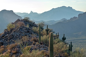
Beautiful views! by phelpsk  Start at Bull Dog Canyon and follow the sandy wash to the jeep trail. You will notice a lot of bullet casings on the ground since people used to target shoot here. Target shooting is NOT permitted now! Stay to the left and up to the non-motorized path. Stay left, and the trail begins at rock cairns. Turn North here. Very well maintained trail by an anonymous hiker. As you follow the trail, you will notice little touches that are fun to discover, like a mini Stonehenge and a nice rock bench for resting. There is a Dead Cow Cave (not sure if there is a dead cow in there). Nice resting spots in the shade and a beautiful view from the top with a nice bench under a palo verde tree. Start at Bull Dog Canyon and follow the sandy wash to the jeep trail. You will notice a lot of bullet casings on the ground since people used to target shoot here. Target shooting is NOT permitted now! Stay to the left and up to the non-motorized path. Stay left, and the trail begins at rock cairns. Turn North here. Very well maintained trail by an anonymous hiker. As you follow the trail, you will notice little touches that are fun to discover, like a mini Stonehenge and a nice rock bench for resting. There is a Dead Cow Cave (not sure if there is a dead cow in there). Nice resting spots in the shade and a beautiful view from the top with a nice bench under a palo verde tree.Lots of cholla, so be careful with doggies! Make sure you wear good tread. The way down can be a bit slippery due to all the gravel.
Sometimes you will see people on the lower horse trails and hear quads on the lower trails. Take plenty of water and a snack. Children can do this hike and genuinely enjoy it if they like the outdoors. The desert flora is prolific, and you will want to take your camera to document all the beauty Feb-April. I especially appreciate the orange Mexican Poppies everywhere! Check out the Official Route and Triplogs. Leave No Trace and +Add a Triplog after your hike to support this local community. | ||||||||||||||||||||||||||||||||||||||||||||||||||||||||||||||||||||||||||||||||||||||||||||