This trail is the Coconino Forestry Service flagship trail. I have hiked this in the middle of summer as well as in the fall. I would say the fall is definitely the best. The Aspen were just at their peak of fall color, and the air was cool and crisp. Who could ask for anything more?
The hike is mildly strenuous because of the elevation. It starts at 9300' and drops to 8800' at the end. It's best done in a two-car shuttle. The second car can park at the Weatherford trailhead. I believe you can reach this trailhead from Friedlein Prairie Road, which is blocked off at a point. I don't think the walk is too bad, and you can park where the roadblock is.
This trail is the best the San Fran peaks have to offer. There are beautiful fir, spruce, and aspen forests, meadows. Early on in the hike, there is an interesting little cave, some basalt cliffs. You'll pass through Friedlein Prairie. This is visible from Flagstaff; it's that big triangle you see when you look up at the peaks. If I even make it this far, I'm lucky. This is a more challenging hike than you might think because of the elevation. I have never gone all the way across as I suffer from elevation sickness and usually poop out at about 3 miles. At one point, you start going uphill at a reasonably respectable climb. It's in a meadow, and the view is fantastic.
It's always a good idea to get acclimated to high elevations before a hike like this. One person in my hiking group this time had hiked in the Himalayas, so this was nothing for her. If you only have one car, Freidlein Prairie is an excellent place to turn around. It's the 4-mile mark. If you are gonzo, you can make it to the Weatherford Trail trailhead and turn around, knock yourself out! I know it would me...
Remember, please keep the dogs on a leash, and if I catch you carving on aspen, I'll pinch your head off.
Coconino FS Details Most trails on the San Francisco Peaks head right for the top of this extinct volcano, the tallest mountain in the state of Arizona. The Kachina Trail breaks this pattern by setting an easy course across some of the mountain's more moderate topography. Don't let that discourage you if you think maximum altitude provides maximum enjoyment. This friendly pathway provides access to a healthy portion of the mountain's most beautiful scenery. Its gently rolling course winds along the mountain's middle slopes almost entirely within the boundaries of the Kachina Peaks Wilderness Area. It follows a moderate gradient through stands of whitebarked aspen and groves of tall mixed conifers separated by broad, wildflower carpeted meadows. Hikers who choose to follow it have an excellent chance of seeing some of the area's more spectacular wildlife residents, including hat-rack antlered elk and mule deer, as well as smaller but easier to see gray squirrels, Clark's nutcrackers, and Steller's jays.
At a number of points, the trail breaks free of the trees to offer good views both of the rocky upper slopes of the mountain and of the forests surrounding its base. Portions of the city of Flagstaff and its suburbs are visible as well. This hike can be especially rewarding in the fall when the scenery rings with the bugling of bull elk gathering harems for the breeding season, and when the mountain slopes glow with the gold of changing leaves. You'll want to bring a picnic lunch to enjoy while you take in all this scenery and don't forget your camera and your binoculars. Bring along a jacket, too. It gets cool up here.
When hiking several trails on a single "hike", log it with a generic name that describes the hike. Then link the trails traveled, check out the example.
WARNING! Hiking and outdoor related sports can be dangerous. Be responsible and prepare for the trip. Study the area you are entering and plan accordingly. Dress for the current and unexpected weather changes. Take plenty of water. Never go alone. Make an itinerary with your plan(s), route(s), destination(s) and expected return time. Give your itinerary to trusted family and/or friends.
Permit $$
no fees or permits reported
if incorrect tell us about it
Directions
Road
FR / Dirt Road / Gravel - Car Okay
To hike From Flagstaff, head off east on highway 180 to the turn off for Snow Bowl. Follow Snow Bowl road to the top where you will see a trail sign and parking area. There is a large graveled parking area(on the right side of the road). It's approximately 300 yds from the Humphries Trailhead(which is on the left side of the road).
 Route Editor

 This trail is the Coconino Forestry Service flagship trail. I have hiked this in the middle of summer as well as in the fall. I would say the fall is definitely the best. The Aspen were just at their peak of fall color, and the air was cool and crisp. Who could ask for anything more?
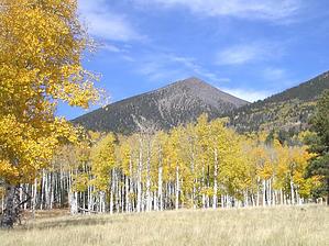


