 Route Editor

| Guide | ♦ | 13 Triplogs | 0 Topics |
details | drive | no permit | forecast | route |
stats |
photos | triplogs | topics | location |
| 145 | 13 | 0 |
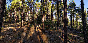
Forest Echoing with Laughter by joebartels   Note NoteThis trail is in the Bill Williams Mountain Watershed. The area is often ordered closed from June until enough moisture is present to reduce the risk of human-caused wildfires. Best check the Kaibab Forest for closures in June and July. Overview C-Shaped connector [ map ] Typically used as one of three lasso loop options. Roundtrip: 1.75 mi / 400 aeg Bill Williams Mtn Trail #21 3.45 mi / 725 aeg Buckskinner Trail #130 3.3 mi / 635 aeg Williams Link Tr #124
Nearby Clover Spring once supplied water for the historic Camp Clover Ranger Station. The station had 425 Christmas trees for sale in 1940. In 1938, the trees were free but you had to be at least 15 years old. Which was welcomed after a 25-50 cent charge in 1937! The tradition moved to Williams in 1944. Girl Scouts Troop 1 ran the sale, 50-75 cents was the going rate. Over the years the spring became less and less reliable. Hike The trail is well signed and used. Likely often maintained based on location and popularity. Ponderosa, fir, Gambel Oak, and a few Alligator Junipers present a quaint forest experience. A counterclockwise hike will feel easier descending the steepest tenth of a mile north of the Buckskinner junction. This ESE corner on of the trail is slightly gnarly, a nice change of scenery. Synopsis If you enjoy a pine forest hike this is among the best of easier options in Arizona. Fantastic in my opinion. Peak baggers could utilize this trail for a slight variation along Bill Williams Mountain Trail #21. For a longer summit hike via Buckskinner or Williams City Link.
Check out the Official Route and Triplogs. Leave No Trace and +Add a Triplog after your hike to support this local community. One-Way Notice This hike is listed as One-Way. When hiking several trails on a single "hike", log it with a generic name that describes the hike. Then link the trails traveled, check out the example. | |||||||||||||||||||||||||||||||||||||||||||||||||||||||||||||||||||||||||||||||||||||||||||||||||||||||||||||||||||||||||||||||||||||||||||||||||||||||||||||||||||||||||||||||||||


