Route Editor

| Guide | ♦ | 27 Triplogs | 2 Topics |
details | drive | permit | forecast | 🔥 route |
stats |
photos | triplogs | topics | location |
| 253 | 27 | 2 |
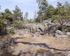
Flagstaff's only waterfall by fotogirl53   Picture Canyon, once a well-kept secret known to only a few in Flagstaff, was dedicated as a National Historic Site on April 29, 2008. Because it has been in the local newspaper and on local TV news, I think it is time to announce this archaeological gem to HAZ. Picture Canyon is technically inside Flagstaff city limits, but it is a part of state trust land. Despite its location near cinder mining, a water treatment plant and a very noisy El Paso natural gas compression station, the prehistoric significance of this place is amAZing. Picture Canyon, once a well-kept secret known to only a few in Flagstaff, was dedicated as a National Historic Site on April 29, 2008. Because it has been in the local newspaper and on local TV news, I think it is time to announce this archaeological gem to HAZ. Picture Canyon is technically inside Flagstaff city limits, but it is a part of state trust land. Despite its location near cinder mining, a water treatment plant and a very noisy El Paso natural gas compression station, the prehistoric significance of this place is amAZing.Over 150 petroglyphs of archers, turtles, deer, elk, bighorn sheep, water birds, and geometric designs were made by the northern Sinagua who farmed and lived here between 1,000 and 1,200 A.D. There are pit houses, cave dwellings, agave roasting pits, and pottery sherds.
The canyon's recent history included being a dumping ground for old cars, mattresses, and other types of garbage. It is State Trust Land, but a group of dedicated Flagstaff residents took it upon themselves to clean out the trash and get it placed on the National Historic Register in an attempt to save it from development. Cranes were used to remove 6 old cars and chunks of concrete. Hundreds of volunteer hours have cleaned up most of the area. In 2007, paintballers left their mark, but volunteers were able to safely clean up most of the damage. You can find pictures of the clean-up if you search the web for "Picture Canyon Flagstaff". The canyon carries the Rio de Flag, Flagstaff's only natural watercourse. Today, however, the water from the Rio de Flag is captured, and what feeds Picture Canyon is reclaimed wastewater, graded A+. In the winter months, the flow is steady and high; in the summer, it is diverted to supply Flagstaff with water for landscaping needs--parks, soccer fields, etc. The water leaves the Wildcat Hill Water Treatment Plant smelling like chlorine (like a hot tub), and foamy. The local wildlife (birds, elk, deer, coyote, rabbits, etc.) just think it is a rare riparian area. The water is chemically clean, but humans are advised not to drink it. Just yards from the treatment plant, follow the Rio de Flag until it drops down the lava at the beginning of the canyon in Flagstaff's only waterfall. No formal trail system exists for this area, but people/game trails make their way northeast downcanyon. You can also enter the canyon from further downstream--just keep walking on the road on top (north side) to the crest of the hill, then find a trail down. Now the fun begins. Check the cliff face for petroglyphs, but don't forget to check the huge boulders, too. Some of the largest panels are on top of these boulders! Plan to spend a fair amount of time looking all around. Some bouldering will be needed as you explore the entire canyon and be prepared to navigate over/under fallen timber. Beware of the New Mexico Locust thorns and yucca plants. A large cave, once a Sinagua dwelling, has a rubble wall in front. Potsherds can also be found here. Another downside to the canyon is the problem with non-native plants, including Scotch Thistle and Bull Thistle. New Mexico Locust is taking hold here. Volunteers regularly try to eradicate, but so far it is a losing battle. Despite its shortcomings, Picture Canyon is a great place to explore Sinagua petroglyphs of people, animals, and geometric forms. Birdwatchers have noted many species, including hawks, ravens, thrushes, mountain bluebirds, buntings, and ducks. Check out the Official Route and Triplogs. Leave No Trace and +Add a Triplog after your hike to support this local community. | ||||||||||||||||||||||||||||||||||||||||||||||||||||||||||||||||||||||||||||||||||||||||||||||||||||||||||||||||||||||||||||||||||||||||||||||||||||||||||||||||||||||||||||||||||||||||||||||||||||||||