Route Editor

| Guide | ♦ | 108 Triplogs | 0 Topics |
details | drive | no permit | forecast | 🔥 route |
stats |
photos | triplogs | topics | location |
| 610 | 108 | 0 |
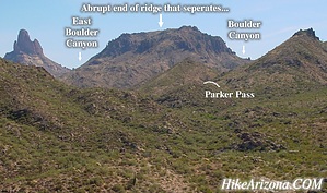
Central Avenue by joebartels  Prologue PrologueFirst Water Trailhead to Parker Pass is a popular stretch of trail in the Superstition Wilderness. This is probably oversimplified for most. Newcomers to hiking searching for a close-to-the-city beginner-trail will find this a good introduction. First and foremost... The best time of year to hike the western Superstition Wilderness is from November to mid-March. From First Water Trailhead, you will follow the Dutchman Trail #104 to Parker Pass. There is no water available at the trailhead. The only water available on route is First Water Creek. ( which is referred to as FWC )
A little background on the flow of FWC... Its origin is just northeast of a ridge with an elevation reading of "4542" on Superstition Mountain. So it comes down from Superstition Mountain swiftly, then zig-zags along a section of the Dutchman Trail. Eventually, it scurries on down to Canyon Lake. First Water Creek terminates into that alcove of the first bridge you cross at Canyon Lake. Hmm... interesting! Hike Okay, let's get on the trail already... There's a good chance a forest ranger will greet you in season. Usually a friendly hello, and they remind you to pack out ALL your trash. A trail heading away from the restrooms isn't the trail. The trail you want is across the parking lot from the bathrooms, near the large panel signage. The first section goes down huge flat white-ish slabs of rock. In about a quarter-mile or 5-7 minutes, you come to the Second Water Trail #236 junction. Second Water shoots off to the left and looks more maintained. Continue straight / right on the Dutchman. The first creek crossing isn't FWC. It's a major feeder coming from the Massacre Grounds and ultimately from the upper reaches of Superstition Mountain too. The next seven creek crossings are FWC. The trail goes from open to brushy. On your right will be numerous rock formations along the way. I should mention this is also a popular horse trail. So beware of the steaming land mines. Remember horses get the ride of way, step aside, and let them pass. I want to say this trail is a no-brainer, and you can't get lost. Though it's unlikely, there is one iffy junction. Right after the very first crossing of FWC, you might wonder where to go. Just remember to stay right. The left circles a knoll and is also a crossover to Second Water Trail. Continue on the Dutchman crossing all seven creek crossings. There's a nice (very)mini hidden canyon if you follow the creek. It's somewhere between crossings 3 and 4, I think. It looks like there's enough dip to get a swimming hole going after a rain. However, it would be rocky on the bottom! You probably shouldn't be out here when it's warm enough to swim anyway, so forget that altogether. About 5-8 minutes after the last crossing, the trail lifts to a saddle. This isn't Parker Pass. I've dubbed this saddle Stingray Saddle. From Parker Pass, the saddle looks like a white Stingray lying in the desert. Trust me...lol It's 1.55 miles to "Stingray Saddle" and only 200 feet of elevation gain you'll barely notice. From here, the trail drops down a bit. Then it continues up to Parker Pass at 2.3 miles. The views from Parker Pass are fair at best. Once you get the Superstition bug, you'll want to go further. A loop with Black Mesa is an easy and popular option if you think you can hang out for 8.5 miles. If the creeks are flowing, a great option is "Upper First Water Creek". Maybe even up the ante with another 3.5 to 4 miles to Weavers Needle for a hearty outing. If that's too easy, try going up to the top of Black Top Mesa. Which is another 3.5 miles and straight up. Oh yeah, the whole idea here was an introduction to the Superstitions. Since this really isn't an exciting trail up to Parker Pass, I've put a little meat on the bone. You might have noticed faint trails-of-use leading away on route to Parker Pass. I checked out all I found, and here's my favorite. From "Stingray Saddle", use-trails are head off both sides. Take the one heading northeast, not southwest. ( think Four Peaks ) It heads straight up from the saddle. Watch out for cacti, more so the possibility of sliding back onto one. Once on top, you'll have some nice views and the possibility to play on what I call the "Fins". ( not for kids! ) On top, looking north-ish, you have two thin fins on the left. ( think I labeled them twin fins in the photos ) In the middle is the upper wide fin. On the right is the main mound, which is probably the safest option. I wouldn't go on the twin fins, but I'm sure some bright soles have. The upper wide fin is doable, with a very minor move. In all honesty, the views aren't any better from up there, but it's kinda fun if you're really bored. At any rate... from somewhere up there, you can get in great views, including the Four Peaks, a full view of Black Mesa, Weavers Needle, the terminus of the ridge between East Boulder Canyon & Boulder Canyon, Superstition Peak, a section of the Ridgeline, and the full trail back to the trailhead if you squint really hard. Check out the Official Route and Triplogs. Leave No Trace and +Add a Triplog after your hike to support this local community. | |||||||||||||||||||||||||||||||||||||||||||||||||||||||||||||||||||||||||||||||||||||||||||||||||||||||||||||||||||||||||||||||||||||||||||||||||||||||||||||||||||||||||||||||||||||||||||||||||||||||||||||||||||