Wine Country (Imagination Required) by HAZ_Hikebot
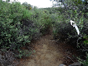
Ninety(90%) percent of this now "very" overgrown trail with some deadfall trees to negotiate was once an old Jeep road for Uranium mining access which contours under the high and scenic bluffs of the Sierra Ancha Wilderness north to south, generally paralleling "out of hearing range & sight" Cherry Creek Road(FR203); This 4.3mi "one-way" trail ends at the intersection of the Sierra Ancha- Lucky Strike Trail#144 (cairned but not signed as of this posting at waypoint: N33 51.863 W110 53.655);
WARNING! Hiking and outdoor related sports can be dangerous. Be responsible and prepare for the trip. Study the area you are entering and plan accordingly. Dress for the current and unexpected weather changes. Take plenty of water. Never go alone. Make an itinerary with your plan(s), route(s), destination(s) and expected return time. Give your itinerary to trusted family and/or friends.
Permit $$
None
Directions
Road
Strictly 4x4
To hike From Phoenix: Take Hwy 60E to Globe; In Globe turn Left on Hwy 188; Continue on 188 to the intersection of Young Hwy 288; Turn Right on 288 and continue for 36 miles to MP294.9 at Board Tree Saddle/FR203(signed) at 5900'elev and waypoint: N33 58.108 W110 57.116; Turn Right on FR203(upper end of Cherry Creek Rd.) and continue for 8.9 rough-downhill 4x4 road miles to TH Start of Grapevine Trail#135(signed on Right) at waypoint: N33 54.144 W110 54.365; Parking is 300ft past TH on Left side of FR203;
page created by Grasshopper on Mar 22 2009 3:31 pm
 Route Editor


 Ninety(90%) percent of this now "very" overgrown trail with some deadfall trees to negotiate was once an old Jeep road for Uranium mining access which contours under the high and scenic bluffs of the Sierra Ancha Wilderness north to south, generally paralleling "out of hearing range & sight" Cherry Creek Road(FR203); This 4.3mi "one-way" trail ends at the intersection of the Sierra Ancha- Lucky Strike Trail#144 (cairned but not signed as of this posting at waypoint: N33 51.863 W110 53.655);