Route Editor

| Guide | ♦ | 3 Triplogs | 0 Topics |
details | drive | permit | forecast | route |
stats |
photos | triplogs | topics | location |
| 26 | 3 | 0 |
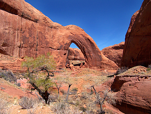
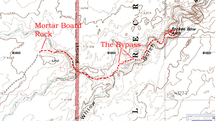
Nothing wrong with this one! by PaleoRob  Willow Gulch starts on the eastern flanks of 50 Mile Mountain, and after cutting through the Sooner Bench, it drops towards the Escalante River (or Lake Powell, depending on how high the lake is). While most of the course is not terribly spectacular, during the last 8 miles or so it cuts a gorgeous, winding canyon deep into the burnt orange Navajo Sandstone, possibly the most beautiful of all rock formations. It is in this last gasp of Willow Gulch that Broken Bow Arch lays hidden.
This side canyon is dry but pretty. You are now surrounded by red rock cliffs, and a low slot appears on and off in the bed of the canyon. Generally skirt this slot, though if you have extra time you can enter and explore. It never gets much deeper than 5-6 feet, however. Near the end of the unnamed canyon, however, you climb down into the slot as it dumps into a four-way canyon intersection. From the mouth of the slot, another unnamed canyon drains in on the left (east-northeast), while Cottonwood Wash enters from the right (west-southwest). Cottonwood Wash is usually dry, and it heads through a semi-narrow stretch directly in front of you, generally trending southeast. The location of the four way is here. There are usually cairns marking the correct route back up canyon, for your return. For heading to the arch, simply continue downstream directly in front of you. About a quarter mile past the four way, you will begin noticing willows and cottonwoods in the wash bottom. The wash bottom also begins to become damp sand. Not much further past these signs Cottonwood Wash enters into Willow Gulch in a willow thicket. Willow Gulch flows generally west to east, so at the intersection turn left. There are occasionally hiker-created trails through the willows, but it also easy to hike along the creek bed, which is now showing stagnant pools and the first signs of flowing water. After hiking along the creek bed for about 100-150 yards, you should notice a trail leading out of the creek bed to the left, up onto the sandy bench and towards a redrock dome in the distance. This is The Bypass which will cut off a couple stream meanders by going up and over a dune and around the redrock dome, making the hike marginally shorter. It also makes it much hotter in the summer, as there is no shade along this portion of the trail, so summer hikers may wish to stick to the creek bed. The Bypass rejoins the creek on the east side of the redrock dome on the creek's floodplain. Here you walk across a shady bench under several cottonwoods. Some of the logs on the ground show evidence of beaver activity, though no beavers or dams were noted during March 2009. From there the trail skirts a rincon from an abandoned meander and enters a section of low narrows, with a massive towering cliff directly in front of you. If there is any chance of rain in the Willow Gulch drainage, it would not be a good idea to do this hike, as this section of the hike provides no escape routes until you make it to the next bend in the canyon. The creek is flowing deeper and faster now, and small fish are visible in some of the pools. The creek bends right and then left again, and as you come around the bend you catch your first glimpse of Broken Bow Arch. Named in the 1930's by either river runners or Herbert Gregory (my sources aren't entirely clear), the 94' wide, 100' tall arch derives its moniker from a prehistoric bow found broken by it's namer under the span. While some good photos can be had of the arch from the first viewpoint, the best vantage is just beyond, atop the sand dune just upstream of the arch. Here you can see the stream undercutting the rock beneath the arch, as well as having an unobstructed view of the arch itself. Because of the undercutting on the western side of the arch, if you wish to sit beneath the span you'll need to walk around to the eastern side and climb the sand dune there to gain access to the backside and then into the eye of the needle! Adventurous hikers can continue down canyon for a ways to either Fortymile Gulch or all the way down to Lake Powell/Escalante River, depending on time and interest. It is possible, though not terribly popular, to make a loop hike down Fortymile Gulch via Carcass Wash to Willow Gulch, then up to the arch and out to the Willow Gulch trailhead. At every canyon junction, take note of your landmarks so that you can pick the correct route when you are hiking back to the car. Also be sure to fill your water bottles (as needed) before getting onto The Bypass during the return trip; the water above the bypass is generally not deep enough to filter or fill a bottle easily with. Despite the short distance (less than 5 miles round trip), this can be a very hot hike, especially during the summer. I drank 3 liters of water in March on this trip, and should have probably done at least 4, for a 3.5 hour hike plus .5 hour break at the arch. You've got water in the canyon, there is no excuse not to be hydrated!
Check out the Official Route and Triplogs. Leave No Trace and +Add a Triplog after your hike to support this local community. | |||||||||||||||||||||||||||||||||||||||||||||||||||||||||||||||||||||||||||||||||||||