Route Editor

| Guide | ♦ | 9 Triplogs | 0 Topics |
details | drive | no permit | forecast | route |
stats |
photos | triplogs | topics | location |
| 163 | 9 | 0 |
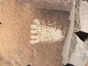
  Nampaweap is an easy to reach rock art site in the Parashant Monument. According to the forest service, the site contains one of the largest concentrations of petroglyphs in the state of Arizona. From the trailhead parking lot, follow the road like path to the sign-in register and obvious single track trail leading to the fields of black volcanic rock that contain the etched images. Allow for a couple of hours to explore the rocks and figure for about a 1.5-mile round trip hike with barely 200 feet of elevation gained. Wear sturdy shoes. Nampaweap is an easy to reach rock art site in the Parashant Monument. According to the forest service, the site contains one of the largest concentrations of petroglyphs in the state of Arizona. From the trailhead parking lot, follow the road like path to the sign-in register and obvious single track trail leading to the fields of black volcanic rock that contain the etched images. Allow for a couple of hours to explore the rocks and figure for about a 1.5-mile round trip hike with barely 200 feet of elevation gained. Wear sturdy shoes.Check out the Official Route and Triplogs. Leave No Trace and +Add a Triplog after your hike to support this local community. | ||||||||||||||||||||||||||||||||||||||||||||||||||||||||||||||||||||||||||||||||||||||||||||||||||||||||||||||||||||||||||||||||||||||||||||||||||||||||||||||||||||||