Route Editor

| Guide | ♦ | 51 Triplogs | 1 Topic |
details | drive | no permit | forecast | map |
stats |
photos | triplogs | topic | location |
| 577 | 51 | 1 |
Canyons are inherently risky. Flash floods occur without notice on sunny days. Technical skills & surrounding topography knowledge required yet does not eliminate risk.
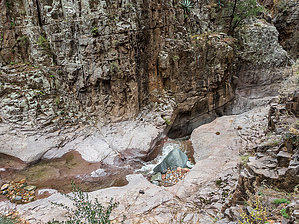
No ropes required (until they are) by eru  Overview: Overview:If you're interested in the full Grade 3 canyon, check the triplogs & alternate route. This guide is for a short (but still quite nice) upper segment that is straightforward Grade 1 (straightforward Class 2/3 using the Yosemite Decimal System) off of FR488 (4WD past the first parking area just past the bridge). Multiple dryfalls (waterfalls in season!) to rappel if you're going further down - but this non-technical section is pretty great for the effort required!
There are a few ways to get down, this looked the simplest. You could also follow Parker Creek from further upstream and drop down some ledgey rocks on the western side of Pocket Creek. From FR488 (past a few 4WD sections) drop-down near an old mostly filled-in mine towards the cement spillway where Pocket Creek enters Parker Creek. You'll end up at a rock face facing the spillway with simple chunky steps down. From here you can make your way down canyon - there's a few deep pools you could either swim, wade in lower water, or bypass pretty easily. Some of the bedrock is quite smooth, step carefully. Most of the rocks in the creek itself are much newer and are quite grippy though! We were never more than boot high in water doing this in January 2022. The canyon tightens as you go down, but there's nothing of consequence until you reach a short falls right before the first rappel point. It's a far enough drop that I'm not sure you'd be able to get up on your own without rope given that you'd be in relatively deep water trying to climb up an overhanging ledge a decent height above. This area slopes downward and is fairly smooth, so be extremely thoughtful about foot placement! Just before this end area, you can easily climb up to a ledge below a tight gully leading out of the canyon and follow it out to a Yucca where you can see where the second rappel point would be. Make your way back out and enjoy the pools. I tried to keep my bootprints out of the sand along the banks as an aesthetic courtesy to others coming down later when reasonably possible. Parking: You could park off the side of FR488 just past where the alternate GPS route drops down if you have a 4WD vehicle. Otherwise park either across FR488 slightly north on 288, at a turnout that can fit 2-3 vehicles (probably used as a camp sometimes) off of FR488 just after the bridge, or if necessary further away on 288. It's only ~2.7mi roundtrip from the large pullout across 288, and it'd be worth tagging in a viewpoint further down FR488 where it wraps into a flat U. Check out the Triplogs. Leave No Trace and +Add a Triplog after your canyon trip to support this local community. | |||||||||||||||||||||||||||||||||||||||||||||||||||||||||||||||||||||||||||||||||