|
tap row or icons for details
|
| Difficulty |
|
2.5 of 5 |
| Route Finding |
|
3 of 5 |
| Distance One Way |
|
2 miles |
| Trailhead Elevation |
|
4,940 feet |
| Elevation Gain |
|
125 feet |
| Accumulated Gain |
|
310 feet |
| Avg Time One Way |
|
2-4 hours |
| Kokopelli Seeds |
|
3.03 |
| Interest Off-Trail Hiking, Ruins & Historic | | Backpack Possible - Not Popular | | unreported if dogs are allowed
editedit > ops > dogs to adjust |
| | |
|
|
51 |
2018-09-24 | Steph_and_Blake |
|
|
10 |
2018-04-25 | AZLOT69 |
|
| |
|
|
|
list |
map |
done |
Southeast Region |
| | |
|
| |
|
|
Historical Weather |
| Trailhead Forecast | | |
|
 |
|
|
| Preferred Oct, Apr, May, Mar → 8 AM |
|
|
|
Seasons Late Spring to Early Autumn |
|
|
| | |
| |
Named Locations Coordinate Links
| |
|
| help future hikers |
| post a gps route now |
| | |
| |
|
|
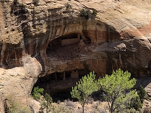
  Enroute to this hike the road passes thru a section of the Ute Indian reservation. It is signed and visitors should avoid trespassing on private land. The hike, however is on public land. From the trailhead follow the jeep road about a quarter mile to the end. Continue across the sidekick as it narrows and becomes a slick rock finger of rock with box canyons off below on either side. Stay high and centered following the finger out. There are huge rock alcoves all over the area. Look left down in the box canyon to see Over Under Ruins. To visit them continue out the finger as it descends toward the canyon bottom. Watch for the trail on the left as it descends a few more benches, to the drainage at the bottom. Over Under Ruins are to your left however, from the bottom up directly above is a Granary with rock art. Check it out then return to the drainage and head over to the main ruins. The lower ruins are accessible but I didn't see any way to see the upper ruins and from a distance they look very well preserved. When done return the way you came or not, the area is quite inviting to the curious. One-Way NoticeThis hike is listed as One-Way. When hiking several trails on a single "hike", log it with a generic name that describes the hike. Then link the trails traveled, check out the example. |
 Route Editor


