Route Editor

| Guide | ♦ | 1 Triplog | 0 Topics |
details | drive | no permit | forecast | map |
stats |
photos | triplog | topics | location |
| 6 | 1 | 0 |
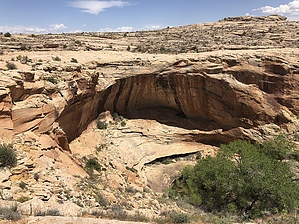
Look out below by AZLOT69 A somewhat typical hike for Combs Ridge. Not too long a hike, great ruins to see, but classify this one under seldom visited. At the trailhead is a monument paying tribute to Mormon settlers who nearly starved to death at this location in their push into uncharted regions. The wash is named after one of them, Hobbs. Hike From the trailhead cross the highway to the south side and follow an old road down to Hobbs Wash. Turn left on the wash. It starts out sandy but soon turns into slick rock. Soon you will arrive at a forty foot drop off. Bear right and follow the right bank around. You may pick up a faint trail. Butler Wash comes into view. You are about one hundred feet above the wash. As you approach Butler Wash continue to follow the bank to your right keeping the wash in sight. At this point you are directly above the alcove containing the ruins. Looking up and down Butler Wash you can see several alcoves. Most don't contain ruins. What was the ancients selection process ? Continue along the bank and watch for cairns. There will be a stairway so to speak down towards the bottom of the wash. At about thirty feet above the wash there it's a ledge. Turn left here. You can see the alcove now ahead of you about three hundred feet. The narrow ledge presents some moderate exposure, not for the faint of heart. Not much of a trail exits but work your way over to the alcove. Enjoy and return the way you came. Check out the Triplog. Leave No Trace and +Add a Triplog after your hike to support this local community. | |||||||||||||||||||||||||||||||||||||||||||||||||||||||||||||||||||||||||||||||||||||||