username
X
password
register
for free!
help
 This is likely a great time to hike this trail!  Check out "Preferred" months below, keep in mind this is an estimate.
  

Tropic Trail, UT

Guide 2 Triplogs  0 Topics
  3.5 of 5  
Fav
Wish
1
details
drive
permit
forecast
map
stats
photos
triplogs
topics
location
9 2 0
Statistics
tap row or icons for details
Difficulty 2 of 5
Route Finding 1 of 5
Distance One Way 1.8 miles
Trailhead Elevation 6,882 feet
Elevation Gain 600 feet
Avg Time One Way 1 hour
Kokopelli Seeds 3.8
 Interest Seasonal Creek
 Backpack No
 Dogs not allowed
feature photo
Photos Viewed All MineFollowing
17  2016-10-02
Peek-A-Boo Loop Trail
AZWanderingBear
9  2009-07-11 writelots
Author
author avatar Guides 19
Routes 40
Photos 5,624
Trips 341 map ( 3,929 miles )
Age 52 Female Gender
Location Tucson, AZ
Associated Areas
list map done
Southwest Region
Historical Weather
Trailhead Forecast
Expand Map
Preferred May, Sep, Oct, Apr
Seasons   Summer
Sun  6:04am - 6:49pm
0 Route
 
1 Alternative


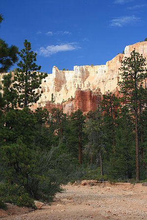
Bryce Canyon NP's Back Door
by writelots

 Likely In-Season!
This trail leaves from the boundary of the Dixie National Forest lands about 5 mi east of the town of Tropic and heads up a wide, gentle canyon to the trail system of Bryce Canyon National Park. The grade is easy, and the trail is wide enough to accommodate 2 hikers side by side. Bryce Canyon is known for its winter splendor, and this trail would likely be easy enough to follow in the snow.


Although the views along this stretch of trail were not nearly as jaw-dropping and wonderful as the other trails in the park which it connects to (Navajo Loop, Queen's Garden Trail, Peek-a-boo Loop and Rim Trail), it is pleasant and a delightful alternative to the crowded trailheads above on the plateau rim. Views of hoodoos, towering red, pink and white tinged cliffs, eroded spires and small arches abound. Additional wonders such as natural bridges, slots between towers and hoodoos that look like English monarchy are just a short hike away from the junction. It also allows hikers to access the park trail system without paying the park entrance fee, if you're into that kind of thing. The town of Tropic boasts a number of lodges and some nice restaurant opportunities as well, as well as providing access to other trailheads in the Dixie National Forest which explore other wonders of the Paunsaugunt Plateau.
remove free decal offer
Bicycles and pets are prohibited on trails within the Park, and backcountry camping is available on the "Below the Rim" trail system in designated campgrounds by permit only. Bryce Creek is typically dry except in times of flood, when caution will need to be exercised crossing. Mud in Bryce Canyon is infamous for it's slick, sucking nature, and has swallowed more than a couple of pairs of loosely tied shoes...

2009-07-13 writelots
  • 2020 Bryce Canyon Visitors Guide
    area related
    2020 Bryce Canyon Visitors Guide


Check out the Triplogs.
Leave No Trace and +Add a Triplog after your hike to support this local community.

One-Way Notice
This hike is listed as One-Way.

When hiking several trails on a single "hike", log it with a generic name that describes the hike. Then link the trails traveled, check out the example.
WARNING! Hiking and outdoor related sports can be dangerous. Be responsible and prepare for the trip. Study the area you are entering and plan accordingly. Dress for the current and unexpected weather changes. Take plenty of water. Never go alone. Make an itinerary with your plan(s), route(s), destination(s) and expected return time. Give your itinerary to trusted family and/or friends.

 Permit $$
None

Bryce Canyon National Park
Per vehicle good for 7 days Entrance Fee Information


 Directions
or
 Road
FR / Dirt Road / Gravel - Car Okay

To hike
From State Highway 12 through the town of Tropic (7 miles east of Bryce Canyon National Park), turn east onto Bryce Way. Follow this approx. 5 miles to trailhead at road end.
page created by writelots on Jul 13 2009 12:29 pm
 90+° 8am - 6pm kills
helpcorrectionissue

end of page marker