Wow, what a great experience! The trail is a cairn adventure. If you follow the oversized constructed cairns, the trip is a breeze. I did some variations and followed the countless trails everywhere. I recommend the cairns on your first trip. From the trailhead, check out the map. The trail is bare-rock in most places making the cairns necessary. The setting is everything I had ever imagined a Sedona hike to be, yet it took me a few years to find it!
Soon into the hike, the task of climbing the sandstone slopes begins. I would never recommend attempting these slopes on a rainy day! For those coming from Tempe, this is very similar terrain to the slopes at the Papago Buttes. The steep angles take some getting used to. They are potentially dangerous if you get off-trail. Some people find getting down is more difficult than going up. Personally, I think getting down is easier; you slide on your butt. I know for those that hike this area regularly, it's no big deal. The reason you see folks standing idle on the slopes is obvious; it's a bit scary at first. Please use common sense, and if it seems hard getting up, you might reconsider. If you stick to the bomber-proof cairns, there's only one semi-technical section. To make it even easier, there are a few footsteps carved into the rock.
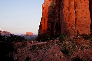
Upon reaching Cathedral Saddle, there is an excellent ledge to the right. Be careful. The views are breathtaking.
WARNING! Hiking and outdoor related sports can be dangerous. Be responsible and prepare for the trip. Study the area you are entering and plan accordingly. Dress for the current and unexpected weather changes. Take plenty of water. Never go alone. Make an itinerary with your plan(s), route(s), destination(s) and expected return time. Give your itinerary to trusted family and/or friends.
Permit $$
Red Rock Pass - may or may not be required. Go to Red Rock Pass then check "When is a Red Rock Pass Required?". If you have questions contact the Coconino forest service.
Directions
Road
Paved - Car Okay
To Cathedral Trailhead From Phoenix go North on Highway I-17 to the Sedona Exit which is SR179. Turn left to go to Sedona. Past Oak Creek Village and about 3 miles before the 'Y' in Sedona ( 179/89A ) turn left onto Back O' Beyond Rd. From the turn, it's only about 0.7 miles to the most obvious and usually crowded trail parking area on the left. (Not exact mileage on these directions)
This TH is closed during the Spring Break season (2024: Feb 29th - Apr 21st) and major holidays will be closed to the general public whenever the shuttle is operating (Thur-Sun).
>>> Schedule <<<
From PHX (I-10 & AZ-51) - 1 hr 53 min (119 miles) From TUC (Jct 1-10 & Grant) - 3 hr 39 min (223 miles) From FLG (Jct I-17 & I-40) - 54 min (32.4 miles)
 Route Editor


 Wow, what a great experience! The trail is a cairn adventure. If you follow the oversized constructed cairns, the trip is a breeze. I did some variations and followed the countless trails everywhere. I recommend the cairns on your first trip. From the trailhead, check out the map. The trail is bare-rock in most places making the cairns necessary. The setting is everything I had ever imagined a Sedona hike to be, yet it took me a few years to find it!