username
X
password
register
for free!
help
 This is likely a great time to hike this trail!  Check out "Preferred" months below, keep in mind this is an estimate.
 

Holcomb Pond Nature Area, NY

Guide 1 Triplog  0 Topics
  4 of 5  
Fav
Wish
0
details
drive
no permit
forecast
route  
stats
photos
triplog
topics
location
11 1 0
Statistics
tap row or icons for details
Difficulty 1 of 5
Route Finding 1 of 5
Distance Lasso-Loop 1.1 miles
Trailhead Elevation 1,403 feet
Elevation Gain 104 feet
Accumulated Gain 223 feet
Avg Time Round Trip 30 minutes
Kokopelli Seeds 2.22
 Interest Perennial Creek
 Backpack Possible - Not Popular
feature photo
Photos Viewed All MineFollowing
11  2022-09-20 Mike_W
Author
author avatar Guides 104
Routes 256
Photos 16,118
Trips 528 map ( 2,863 miles )
Age 53 Male Gender
Location Tucson, AZ
Historical Weather
Trailhead Forecast
Radar Map
Expand Map
Preferred May, Sep, Oct, Jun → 9 AM
Seasons   Spring to Autumn
Sun  5:50am - 6:34pm
Official Route
 
0 Alternative


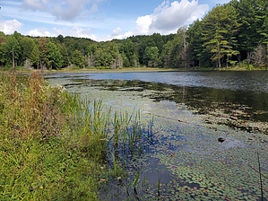
walk around the pond and back
by Mike_W

 Likely In-Season!
Overview
Holcomb pond is a 29-acre pond situated on the Northeast end of the Zoar Valley nature area in Gowanda, New York. Zoar Valley is a 2,978-acre nature area that includes a part of Cattaraugus Creek and which also has unique scenery, including a deep gorge, cliffs, waterfalls, and thick forest.


Hike
From the Holcomb Pond parking area, there will be a trail entrance heading South. Take this trail downhill to Holcomb Pond which will be on your left after 0.2 miles or less. The trail goes around the pond. There are grassy areas and forested areas along the way. There are also a few paths going to the shore of the pond at various stops. I saw a few small frogs jumping around near the border of the pond.
remove free decal offer
There's also a trail on the Northwest end of the pond leading West which is 1.6 miles long and connects to the South end of Unger road. There are a few other ponds 1/2 mile West of Holcomb pond.

2022-09-21 Mike_W


    Check out the Official Route and Triplog.
    Leave No Trace and +Add a Triplog after your hike to support this local community.
    WARNING! Hiking and outdoor related sports can be dangerous. Be responsible and prepare for the trip. Study the area you are entering and plan accordingly. Dress for the current and unexpected weather changes. Take plenty of water. Never go alone. Make an itinerary with your plan(s), route(s), destination(s) and expected return time. Give your itinerary to trusted family and/or friends.

     Permit $$
    None


     Directions
    or
     Road
    Paved - Car Okay

    To hike
    From the center of Gowanda, NY, take E Main St. Northeast 0.2 miles to Gowanda Zoar road and turn right. Take Gowanda Zoar road East 2.6 miles to Unger road and turn right. Take Unger road for 0.5 miles and turn left on Vail road. Take Vail road 0.9 miles. The parking area will be on the right side of the road.
    page created by Mike_W on Sep 21 2022 7:17 am
    helpcorrectionissue

    end of page marker