Route Editor

| Guide | ♦ | 102 Triplogs | 0 Topics |
details | drive | no permit | forecast | 🔥 route |
stats |
photos | triplogs | topics | location |
| 684 | 102 | 0 |
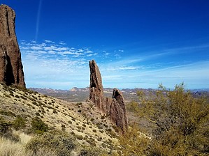
Monumental by AZLOT69  Geology GeologyThe allure of the Superstition Mountains lies in part with the geologic formations within. This hike offers close up views of hoodoos, spires, pinnacles, and arches formed both by the volcanic activity in the area and the subsequent forces of nature. Many of these formations convey a mystic or supernatural feel. Overview While most should be physically capable of completing this hike, substantial footwear and route finding skills may be required to complete the loop.
The loop can be accomplished in either direction and is described herein as counterclockwise. From the Crosscut Trailhead, go thru the horse step in the fence. Directly in front of you on the south bank of Weekes Wash is the return trail. Instead, find the trail leading to the southwest along the south bank of Weeks Wash. There is a signpost, but the sign is gone. This is Jacobs Trail #58. Take Jacobs Trail to the intersection with the Treasure Loop Trail #56 and take it to the left towards the Superstition. Well up the mountain, the trail starts toward the south, take the unmarked trail continuing up and to the east. There are a couple to choose from. Taking the left passage is easier. You can see your immediate destination, the Praying Hands, which is high above to the northeast. Topping out at Praying Hands is an experience in itself and a great place to meditate for a while. There is a fence line here marking the wilderness boundary. Very little vegetation here gives you plenty of places to sit and enjoy. From here, a faint narrow trail continues to the east. Take this trail. The trail gets a little tricky to follow, but there are sufficient cairns that make the trail finding fun. In the distance, to the left of the trail in the foreground lies the next destination. Three separate geologic features are similar to the ones you just experienced behind you at the Praying Hands. The landforms look like temples. The trail continues in that general direction hugging the mountain. The trail comes to a Y. To the right, the trail goes up the mountain. Take the left choice thru the shallow ravine ahead, bearing left directly towards the first spire. It is mainly a bushwhack without much vegetation. As you get close to the spire, you will pick up an animal trail taking you to the base of the spire. From here, continue to the next land feature to the north. There is no right or wrong way. Some loose scree will be the worst you encounter. From around the north side of this feature, the views overlooking the wilderness are fantastic. Four Peaks, Black Mesa, Weekes Wash headwater, First Water Creek, and the Massacre Ramp are just a few of the sights. See how many others you can spot. There is a great camping spot just below this spire to the north. The third temple lies down the ridge directly to the west. With hoodoos above and Praying Hands ahead in the background, this is a photographer's dream. Just wait for the right light. On the north side of the third feature are a smaller set of praying hands. Work your way over to them and take the ramp between them down. From here, continue to the northwest down the ridge. At the first rock outcropping, watch for cairns and angle across the drainage to the north. From here, the wash ahead is clearly visible, chocked with vegetation. Staying to the right of it, work your way thru the jojoba, taking the obvious path of choice. Scan the horizon occasionally as you look for the scarce but strategic cairns. Always bearing left, the trail comes and goes. Whenever you think you lost the trail, bear left to pick it up again. Eventually, you cross the wash on your left and come to an area where the rocks are red. Continue bearing left. Soon the trail becomes more pronounced, and of course, there are more cairns than you need at this point. Soon you come to the wilderness boundary fence again. Passing thru the fence, the trail gets more pronounced. The trail follows a ridgeline down now with large sweeping ravines off either side of the trail. The trail now seems to be an old prospectors jeep trail and is quite easy-going. Eventually, you will come to a forest of cholla. Watch for a small cairn and bear right on the single track back to the Crosscut trailhead. If you miss the turnoff, continuing straight will still take you out to First Water Road, and your vehicle will be to the right. Check out the Official Route and Triplogs. Leave No Trace and +Add a Triplog after your hike to support this local community. | ||||||||||||||||||||||||||||||||||||||||||||||||||||||||||||||||||||||||||||||||||||||||||||||||||||||||||||||||||||||||||||||||||||||||||||||||||||||||||||||||||||||||||||||||||||||||||||||||||||||||||||||||