Route Editor

| Guide | ♦ | 51 Triplogs | 0 Topics |
details | drive | permit | forecast | route |
stats |
photos | triplogs | topics | location |
| 505 | 51 | 0 |
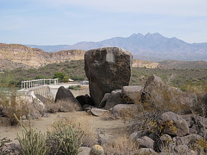
Big Dam Ancient Art by AZLOT69  2022-11-18 douglasalindsay writes about spur trail to glyphs: 2022-11-18 douglasalindsay writes about spur trail to glyphs:giant white sign on fence says NO TRESPASSING - violators will be prosecuted under state & federal law, with potential $2,000 fine. HAZ writes: • Do not enter any area with official signage stating it is closed or no trespassing. • 2022-11-18: no privately owned parcel in this area on the county assessor's map to confirm. Warning The Official Route for this guide starts on private property. See directions for details about fees and other options.
Few if any can recall the appearance of the valley at this location when the Salt River flowed naturally. Precious few photos exist of that time. A time when a ranch occupied the valley where Saguaro Lake now sits. It was owned by the Stewart family. The demise of the Stewart ranch was brought about by the further harnessing of the Salt River by building the Stewart Mountain Dam. The Dam which was constructed from 1928-1930 is 208 feet high and the total length is 1260 feet. Many changes were made to the area in the construction of the dam. The small resort by the trailhead, called Saguaro Lake Ranch was originally a work camp with a bunkhouse and cabins for the dam workers. This hike will combine a great scenic old-growth area of the Sonoran desert. Mix in a birds-eye view of the modern marvel of the Stewart Mountain Dam, and round out the experience with a little exploration leading to petroglyph writings of people who lived here long before the Stewarts. Hike The trail can be accomplished in either direction but is described here counterclockwise. The trail starts near a mesquite tree about forty feet in front of where you parked your car. It serpentines its way up the hill with immediate views east across the Salt River of the dramatic Goldfield Mountains. When you get to the top of the hill the trail levels off and comes to a Y. Take a side trip to the right, where there is a sign saying the trail ends in 500 feet. Take this faint trail several hundred feet to a large rock outcropping. Explore the rock outcropping for petroglyphs. The outcropping overlooks Stewart Mountain Dam, with Four Peaks in the distance beyond the dam and the Goldfields to your right. Continue on the path to the right to the end of the trail and look directly down on the dam. Return to the main trail and turn right. The trail makes another climb and meanders around the natural curves of the mountain offering great views of the dam, mountains, and soon Saguaro Lake and marina. This view is at the next hilltop. Take the Y trail to the right for fifty feet to a nice overlook. Returning to the trail continue right thru old desert growth with some spectacular plant specimens. The terrain becomes quite interesting with boulder outcroppings. As you approach the Bush Highway the trail bends left without crossing. After about a hundred yards of following the road, you will come to a crossing. It's on a bend so listen for cars and hustle across the road as there is no control. Boulders and scenic rock outcroppings are everywhere making for great photo opportunities. The trail comes to another Y. Bear left here. Soon an unusual site appears off to the right. At first, it seems to be a geological anomaly. Tucked into the valley in a vast field of white granite. A closer exam shows this to be a dumpsite for excavated material. The trail continues down into a wash. The wash, known as Horse Thief Wash, received its name back in the Stewart Ranch era for obvious reasons. The wash becomes steep-walled with old-growth ironwoods maintaining strategic footholds. Eventually, you come to a palm tree growing alongside the wash putting you on notice that civilization can not be far away. Coming around a corner two gigantic culverts lie ahead. They are about twenty feet in diameter giving you some idea of the amount of water that can potentially come thru this wash. Walk thru the culvert under the Bush Highway and continue in the wash on the other side. Soon you arrive at the old alignment of the Bush Highway which is closed. Take it to the left to where it joins the Stewart Mountain Dam Road you parked on. Go thru the gate and walk along the road about a quarter-mile to your car completing the loop. Gate Policy: If a gate is closed upon arrival, leave it closed after you go through. If it is open, leave it open. Leaving a closed gate open may put cattle in danger. Closing an open gate may cut them off from water. Please be respectful, leave gates as found. The exception is signage on the gate directing you otherwise. Check out the Official Route and Triplogs. Leave No Trace and +Add a Triplog after your hike to support this local community. | |||||||||||||||||||||||||||||||||||||||||||||||||||||||||||||||||||||||||||||||||||||||||||||||||||||||||||||||||||||||||||||||||||||||||||||||||||||||||||||||||||||||||||||||||||||||||||||