username
X
password
register
for free!
help
 
  🔥

Apache Trail Canyon, AZ

Guide 20 Triplogs  0 Topics
  3.2 of 5  
Fav
Wish
8
details
drive
no permit
forecast
🔥
route  
stats
photos
triplogs
topics
location
161 20 0
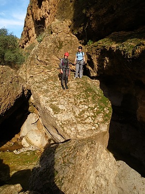
Canyons are inherently risky. Flash floods occur without notice on sunny days. Technical skills & surrounding topography knowledge required yet does not eliminate risk.
Statistics
tap row or icons for details
Distance Round Trip 4.25 miles
Trailhead Elevation 2,495 feet
Elevation Gain -620 feet
Accumulated Gain 861 feet
Kokopelli Seeds 8.56
 Interest Off-Trail Hiking, Seasonal Waterfall & Seasonal Creek
unreported if dogs are allowed
editedit > ops > dogs to adjust
feature photo
Photos Viewed All MineFollowing
Will recalculate on button tap!
12  2024-12-11 fdv75
13  2023-01-21 ddgrunning
3  2015-07-15 CoryTallman
10  2015-04-04 outdoor_lover
11  2015-01-31 oceanwithin
20  2014-03-23 desert_boonie
5  2013-01-27 azflyguy
15  2011-10-31 mikebowers
Page 1,  2
Author
author avatar Guides 16,843
Routes 17,472
Photos 24
Trips 1 map ( 6 miles )
Age 28 Male Gender
Location HAZ, TrailDEX
Historical Weather
Trailhead Forecast
Radar Map
Expand Map
Preferred Oct, Nov, Mar, Apr
Sun  6:03am - 6:43pm
Official Route & 3 Rts
 
0 Alternative
 
Historic Fire Perimetersacres
🔥 2024 Siphon Fire35.9 mi*
🔥 2019 Woodbury Fire123.8k
🔥 View (All) - over Official Route 🔥
*perimeter length in miles


remove free decal offer

 
Guide Needed
Publish Full Detail Guide


Use +Add above to share photos and triplogs
Overview
A technical canyon on the side of the Apache Trail with two rappels into swimmers that can be avoided in colder weather with a rappel downstream of the pools or an exposed down climb followed by a sweet section of small pools and boulder caves. Mileage depends on where you exit (old Apache Trail or up & over the ridge) and how much wandering you do down there


    Check out the Official Route and Triplogs.
    Leave No Trace and +Add a Triplog after your canyon trip to support this local community.
    WARNING! Hiking and outdoor related sports can be dangerous. Be responsible and prepare for the trip. Study the area you are entering and plan accordingly. Dress for the current and unexpected weather changes. Take plenty of water. Never go alone. Make an itinerary with your plan(s), route(s), destination(s) and expected return time. Give your itinerary to trusted family and/or friends.

     Permit $$
    no fees or permits reported

    if incorrect tell us about it


     Directions
    or
     Road
    Paved - Car Okay

    To canyon trip
    East on AZ88, 3.3 miles past Tortilla Flat and park near the power lines.
    page created by Vaporman on Dec 14 2009 9:41 pm
     90+° 8am - 6pm kills
    helpcorrectionissue

    end of page marker