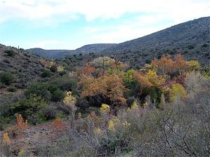
This is a great day hike for when you don't have time to get out of the Phoenix area! It starts out paralleling a picnic area and campgrounds running along Cave Creek. In about 0.5 miles, you pass a private ranch, and then it gets much better. For the first mile or so, this is a level hike following along the creek. This is a multi-use trail for horses and mountain bikes as well, but we never saw any. Many birds in this area, and although we didn't see much wildlife, it's a perfect area for it.
Around 1.9 miles, the trail turns away from the creek for 0.9 mi and then drops into a canyon @ 2.75 mi. There are lots of pools and rocks until 4.1 miles. It was hard to find a good lunch spot because this is the kind of trail you want to keep following to see what's next. Along the way, be on the lookout for a terrific specimen of a crowned saguaro--easy to miss when your eyes are fixed on the stream bed and the water. At 4.3 miles, you can continue following the Cave Creek Trail, which runs about 5+ miles further. You can go back the way you came or take the Skunk Tank Trail #246 to make the loop. (The Cave Creek Trail ends at FR 48, just north of the town of Cave Creek)
Up to now, this trail is easy. The Skunk Tank portion makes this a whole lot tougher. Taking this trail, you get to go up for approximately 1100 feet in the next 2.4 miles. Even with lots of switchbacks, this is a big climb, with lots of little elevation changes and loose footing. There are some really great views on the bright side, looking back down the valley and north to the plateaus. Just before the summit, you will pass Skunk Tank, which was full of water on this trip, but really looks like a cattle pond. You pass through a gate here and continue up a little more.
At the high point, there is a sign pointing right for Quien Sabe Trail. Continue left on #246. At this point, the trail follows an old mining road, and while wide, the footing is pretty loose. Between 7 and 8 miles in, you can see the mine's remains off the hill to the right.
The Cave Creek portion of the trail is the easiest and most scenic, but for those of us who prefer loop trails, this was a great one. We saw 5 other groups of people, all near the creek around mile 2, but had the world to ourselves the rest of the time. (Although I am sure it gets much more crowded as the weather warms up.)
Gate Policy: If a gate is closed upon arrival, leave it closed after you go through. If it is open, leave it open. Leaving a closed gate open may put cattle in danger. Closing an open gate may cut them off from water. Please be respectful, leave gates as found. The exception is signage on the gate directing you otherwise.
WARNING! Hiking and outdoor related sports can be dangerous. Be responsible and prepare for the trip. Study the area you are entering and plan accordingly. Dress for the current and unexpected weather changes. Take plenty of water. Never go alone. Make an itinerary with your plan(s), route(s), destination(s) and expected return time. Give your itinerary to trusted family and/or friends.
Permit $$
None
Directions
Road
FR / Dirt Road / Gravel - Car Okay
To Cave Creek Seven Springs Trailhead Cave Creek TH in the Seven Springs Campground area.
From the intersection of Tom Darlington Rd and Cave Creek Rd, travel East on Cave Creek Rd. At 2.2 miles, you pass Pima Rd. Continue on Cave Creek Rd, and at 6.3 miles, you reach Bartlett Dam Rd. Follow the sign to Seven Springs Rd. At 9.1 miles, you pass the Sears Kay Ruins. The pavement ends at 10.8 miles. You pass the Bronco TH at 13.8 miles, and the road is now marked Forest Road 24. At 17.6 miles, you pass a private ranch. At 17.9 miles, you pass the Seven Springs Campground, and the Cave Creek TH is on your left at 18.5 miles.
2012-03-07 Nahimana222 writes: From the signs I saw at the trailhead, you need a Tonto Pass to park. 2025-11-27 kyleGChiker writes: As of this date, the Forest Service website indicates that this is a fee-free area, with no pass required.
From PHX (I-10 & AZ-51) 51.5 mi - about 1 hour 36 mins From TUC (Jct 1-10 & Grant) 153 mi - about 2 hours 57 mins From FLG (Jct I-17 & I-40) 127 mi - about 2 hours 38 mins
 Route Editor

 This is a great day hike for when you don't have time to get out of the Phoenix area! It starts out paralleling a picnic area and campgrounds running along Cave Creek. In about 0.5 miles, you pass a private ranch, and then it gets much better. For the first mile or so, this is a level hike following along the creek. This is a multi-use trail for horses and mountain bikes as well, but we never saw any. Many birds in this area, and although we didn't see much wildlife, it's a perfect area for it.