Overview
This passage begins on the north side of the Roosevelt Lake Bridge at the Vineyard Trailhead on Highway 188. The trail climbs immediately along Inspiration Point, passes the radio towers, and then passes north of Vineyard Mountain. It climbs up to the Mills Ridge Trailhead and from here Four Peaks Trail #130 continues up and reaches the Four Peaks Wilderness boundary. The trail drops into Buckhorn Creek and then goes up again, passing Hackberry Creek and finally reaching Granite Spring. From here a new section of #130 heads north and then west, skirting around Buckhorn Peak. Heading north again the trail intersects with Alder Creek Trail #82 and then Oak Flat Trail #123 where it turns left and soon reaches Shake Spring. From here the trail works its way north and west to Pigeon Spring, climbs southwest on an old roadbed, and finally comes to the Pigeon Spring Trailhead on FR 648.
When hiking several trails on a single "hike", log it with a generic name that describes the hike. Then link the trails traveled, check out the example.
WARNING! Hiking and outdoor related sports can be dangerous. Be responsible and prepare for the trip. Study the area you are entering and plan accordingly. Dress for the current and unexpected weather changes. Take plenty of water. Never go alone. Make an itinerary with your plan(s), route(s), destination(s) and expected return time. Give your itinerary to trusted family and/or friends.
Permit $$
no fees or permits reported
if incorrect tell us about it
Directions
Road
To hike
page created by joebartels on Jan 09 2010 12:41 am
 Route Editor

 Overview
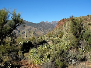


