Route Editor

| Guide | ♦ | 769 Triplogs | 3 Topics |
details | drive | no permit | forecast | route |
stats |
photos | triplogs | topics | location |
| 1.2k | 769 | 3 |
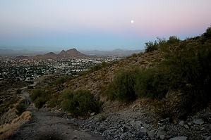
a walk in the park by Brems  This trail has two trailheads. The more popular is on Central Ave, just south of Thunderbird Rd. The other is on 15th Ave, just north of Peoria. Starting from the trailhead on Central, the trail begins as an easy service road. This part of the trail, from the trailhead to the top, is used often by service vehicles to access the vast array of communication towers up on the top. The trail here has relatively easy to moderate inclines that level off for about 25 to 50 yards. This trail has two trailheads. The more popular is on Central Ave, just south of Thunderbird Rd. The other is on 15th Ave, just north of Peoria. Starting from the trailhead on Central, the trail begins as an easy service road. This part of the trail, from the trailhead to the top, is used often by service vehicles to access the vast array of communication towers up on the top. The trail here has relatively easy to moderate inclines that level off for about 25 to 50 yards.When about to the top, there is an obvious fork in the trail. To your left, the service road continues a few more yards up to the antennas, and on your right, the trail will begin to descend the western side of the butte. The deteriorating asphalt soon gives way to a rockier trail. On your right, the trail will begin to continue around to the south side of the butte. This part of the trail is not nearly as busy as the first half. About 1/4 of the way down there are the remains of the old Cloud 9 restaurant that burned down back in Nov 1964. (Date and link clarified by a guest) Although they are a bit vandalized, they are interesting to check out.
If you live in the north valley, this trail is a quiet alternative to the hustle and bustle of Squaw Peak and Camelback. Not nearly the workout, but if solitude is what you seek, this is a nice place to find some. Water faucet with potable water near the trailhead Check out the Official Route and Triplogs. Leave No Trace and +Add a Triplog after your hike to support this local community. | |||||||||||||||||||||||||||||||||||||||||||||||||||||||||||||||||||||||||||||||||||||||||||||||||||||||||||||||||||||||||||||||||||||||||||||||||||||||||||||||||||||||||||||||||||||||||||||||||||||