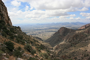
At approx. 5 miles each way, Mt. Kimball is the most accessible major peak in the Catalinas. At 4200 ft. elevation gain, those 5 miles are tough ones. The peak of Mt. Kimball itself is not much to write home about - it's more or less a bunch of trees. There are no towering rock formations to climb up like Window Peak or Cathedral Peak (also in the Catalinas). But there is a small ledge at the very top which offers a stunning 180-degree view of the northwest side of the Catalinas - which is the prettiest and most dramatic view in the range, in my opinion. When you emerge from the trees at the end of the trail, the view will take your breath away. I've been up there several times, and I still gasp at the view every time. Well worth the trip!
From the parking lot, head up the street a short way towards the sign for the Coronado National Forest and jump on the trail. After just a few yards, the trail splits off between the Pontatoc Canyon Trail and the Finger Rock Trail. Head out on the Finger Rock Trail.
The first mile or so of the trail is relatively flat, winding northeast through mesquite and saguaro country towards the valley where you begin your ascent. About the second mile, you head steeply up through the valley, in view of Finger Rock much of the way. (Note: there is no trail leading to Finger Rock itself). The views down into the canyon below are impressive. About three miles into the trip, you will approach a saddle known as Linda Vista. There is an un-marked side-trail that splits off to the right for a short distance to the saddle. Linda Vista is a south-facing saddle with a nice view of Tucson below. It makes for a nice place to take a break or a nice destination for a shorter trip.
Continuing past Linda Vista, you leave the riparian valley for oak and pine country, above and beyond Finger Rock. About mile four or so, you enter a forest of manzanita, and the trail is at its steepest. You will soon reach a Forest Service sign marking the intersection of the Finger Rock Trail and Pima Canyon Trail, noting that Kimball Peak is only 1/2 mile away. Head left* on the Pima Canyon Trail towards the peak. The last 1/2 mile takes you steeply up through a more alpine region to the top of Mt. Kimball. (BTW, at the trail junction, you might want to head just a little way down the Finger Rock trail to the right - there you can catch a great view of the mountains to the north).
* commonly missed turn, just be aware
Important
The trail will seem to top-out at a point where you can see virtually nothing but the trees around you. There is a side trail heading right (or east) just near the top which takes you maybe 50 yards or so to a rocky ledge that offers stunning views to the east, west, and north. Don't head back without making this tiny side trip to the 'real summit'!
WARNING! Hiking and outdoor related sports can be dangerous. Be responsible and prepare for the trip. Study the area you are entering and plan accordingly. Dress for the current and unexpected weather changes. Take plenty of water. Never go alone. Make an itinerary with your plan(s), route(s), destination(s) and expected return time. Give your itinerary to trusted family and/or friends.
Permit $$
None
Coronado Forest MVUMs are rarely necessary to review unless mentioned in the description or directions Coronado Motor Vehicle Use Maps (MVUMs)
Directions
Road
Paved - Car Okay
To hike From the intersection of Swan and Skyline in north Tucson, drive west on Skyline Dr. From Skyline, drive north on N. Alvernon Dr. to the end of the road. Just before N. Alvernon turns into a private drive, there will be a parking lot designated for public use on the west side of the road - park here.
 Route Editor

 At approx. 5 miles each way, Mt. Kimball is the most accessible major peak in the Catalinas. At 4200 ft. elevation gain, those 5 miles are tough ones. The peak of Mt. Kimball itself is not much to write home about - it's more or less a bunch of trees. There are no towering rock formations to climb up like Window Peak or Cathedral Peak (also in the Catalinas). But there is a small ledge at the very top which offers a stunning 180-degree view of the northwest side of the Catalinas - which is the prettiest and most dramatic view in the range, in my opinion. When you emerge from the trees at the end of the trail, the view will take your breath away. I've been up there several times, and I still gasp at the view every time. Well worth the trip!
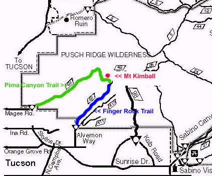 About the second mile, you head steeply up through the valley, in view of Finger Rock much of the way. (Note: there is no trail leading to Finger Rock itself). The views down into the canyon below are impressive. About three miles into the trip, you will approach a saddle known as Linda Vista. There is an un-marked side-trail that splits off to the right for a short distance to the saddle. Linda Vista is a south-facing saddle with a nice view of Tucson below. It makes for a nice place to take a break or a nice destination for a shorter trip.