Route Editor

| Guide | ♦ | 572 Triplogs | 1 Topic |
details | drive | no permit | forecast | route |
stats |
photos | triplogs | topic | location |
| 636 | 572 | 1 |
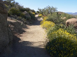
incredible vistas by lobo41  Pinnacle Peak Park in Scottsdale, closed for over 6 years because of luxury home development, reopened Saturday, April 20, 2002. Pinnacle Peak Park offers a 3.5-mile round trip interpretive hiking trail. (The trail is also open to experienced horseback riders, but we did not see any on our hike.) The park is open every day, except Christmas from dawn until dusk. Thanksgiving from 6:45a until 5p and New Year's Day from 7a until 5p. There is a Park Office, restrooms, shade ramada, picnic tables, and ample parking at the trailhead. There are also three rock-climbing areas. Best of all, there is no fee to enter the park. Pinnacle Peak Park in Scottsdale, closed for over 6 years because of luxury home development, reopened Saturday, April 20, 2002. Pinnacle Peak Park offers a 3.5-mile round trip interpretive hiking trail. (The trail is also open to experienced horseback riders, but we did not see any on our hike.) The park is open every day, except Christmas from dawn until dusk. Thanksgiving from 6:45a until 5p and New Year's Day from 7a until 5p. There is a Park Office, restrooms, shade ramada, picnic tables, and ample parking at the trailhead. There are also three rock-climbing areas. Best of all, there is no fee to enter the park.The Pinnacle Peak trail skirts around the prominent 3,171-foot valley landmark. It is not a loop trail. Hikers should not let the fairly minimal height gain deceive you, there are enough ups and downs on the trail to give even the most seasoned hiker a workout. The trail is in excellent condition and, In most places, it is wide enough for two people to walk abreast. Along the trail, the Park has numbered the various plant life to assist with identifying them. They also have ample signs to indicate the distance to/from the trailhead.
At this point, the trail passes over to the west side of Pinnacle Peak. Between the .75 and 1.25, a series of switchbacks takes the trail down, across a saddle, and back up again. This section of the trail provides an excellent overview of Estancia Golf Club and some of the luxury homes along its well-manicured fairways. From the 1.25 mark, with the help of another series of switchbacks, it's a fairly rapid descent to the 1.75 mark and the western end of the trail. There is no parking at the western end so your only option is to return the way you came. The climb from the western end of the trail to the 1.25 mark is physically the most demanding part of this hike. This is a very enjoyable hike that will surely become a favorite of those in the Northeast Valley. Check out the Official Route and Triplogs. Leave No Trace and +Add a Triplog after your hike to support this local community. | ||||||||||||||||||||||||||||||||||||||||||||||||||||||||||||||||||||||||||||||||||||||||||||||||||||||||||||||||||||||||||||||||||||||||||||||||||||||||||||||||||||||||||||||||