 Route Editor

| Guide | ♦ | 137 Triplogs | 1 Topic |
details | drive | permit | forecast | 🔥 route |
stats |
photos | triplogs | topic | location |
| 505 | 137 | 1 |
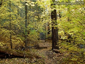
AZ by joebartels  Note NoteThe 2003 Aspen Fire slightly scorched this once beautiful area. You will enjoy this combination hike. From the Marshall Gulch Parking area, the trailheads are very near the restrooms. The Marshall Gulch trail takes off behind the bathrooms. The Aspen trailhead is just left of the men's restrooms. Take either trail. I opted for the Aspen going up and the Marshall Gulch on the return. I hiked this on a Monday, the day after the fourth of July. This was without a doubt the most popular playing everywhere made this a picture-perfect holiday. Signs along the road marked no parking couldn't hold this crowd back. The road was lined with cars for over a half-mile. Okay, onto the Aspen trail. The setting is a classic pine forest. Looking over the most memorable picnic area I have ever seen, the trail ascends straight up. The trail veers right, and you pass shiny quartz (I think) scattered all over the trail. Thick pines, stands of Aspen, and ferns lining the ground surround you. Trail maintenance is excellent. Trees obviously frequently fall in this area; credit the forest service for clearing the way. After about a quarter-mile, you pass the Coronado Wilderness boundary. Immediately after the Wilderness boundary, the trail begins to switch back. Leveling off again, a beautiful scene lies ahead. Several young oaks (I think) slant over the trail making for a nice picture. Approaching the same area, take a moment and look over your right shoulder. This is great you are looking right into a stand of Aspens at mid-level. I believe that's the last stand of Aspens passed on the trail. Notice only extremely large Aspens remain here as they are getting choked out by the pines. Some day soon, they may have to rename this trail.
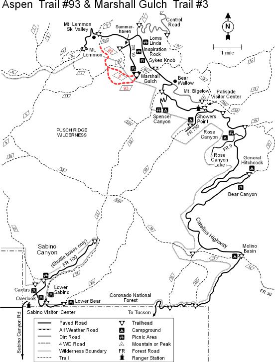
I arrive at the junction. Trails connecting are Marshall Gulch #3, the continuation of the Aspen #93 up to the top of Mt. Lemmon, Mint Spring #20, and the Wilderness of Rock Trail #44. Under the #44 sign reads, "This area has been impacted by overuse, please practice low impact backcountry ethics". I opt to return on Marsh Gulch #3, which descends immediately. Ferns are plentiful on this trail. I notice this seems to be the more popular trail of the two. Whereas I only passed a few hikers on the #93, this is a freeway. Not to worry, this area is well worth it. My senses at this point are on overload. I am in awe of the never-ending beauty along the way. The Marshall Gulch follows a drainage that gets my approval. The trail winds and dips. Vegetation is lush like I would have never imagined for Southern Arizona. This is Arizona's finest combo trail I have hiked to date. The Aspen #93 was everything I had hoped for, and the Marshall Gulch delivered an unexpected sensory overload.
Coronado FS Details The loop formed by these two trails is one of the most heavily used upper elevation routes into the Pusch Ridge Wilderness. This moderate hike leads through an area of diverse habitats that include excellent examples of Canadian Zone riparian areas and ponderosa pine forests. If you are a bit of an amateur naturalist, you might want to bring a guide to Arizona's trees as well. You'll see quite a few different species along this trail which changes aspect and life zones as it loops around a false summit of Marshall Peak. You'll find aspens here, of course, but you'll also pass by Douglas and White Fir, Gambel and Silverleaf Oak, red-barked Madrone and more. Notable sights along this trail include the bare granite walls of the uppermost reaches of Sabino Canyon, through which the first half mile or so of the Aspen Trail passes. Along this part of the route the pathway literally sparkles with flakes of mica and quartz. After taking in the wide angle overlooks at Lunch Ledge and Marshall Saddle, both of which include overlooks of the Wilderness of Rock area, towering Lemmon Rock, and Romero Pass, take the Marshall Gulch Trail back to your starting point. It leads down a cool, shady canyon which is usually well stocked with wildflowers and pleasant little pools. Attractions: Great views Scenic canyon Cool mountain setting Fall colors Easy access Check out the Official Route and Triplogs. Leave No Trace and +Add a Triplog after your hike to support this local community. | ||||||||||||||||||||||||||||||||||||||||||||||||||||||||||||||||||||||||||||||||||||||||||||||||||||||||||||||||||||||||||||||||||||||||||||||||||||||||||||||||||||||||||||||||||||||||||||||||||||||||||||||||||||||||||||||||||


