Route Editor

| Guide | ♦ | 44 Triplogs | 10 Topics |
details | drive | permit | forecast | route |
stats |
photos | triplogs | topics | location |
| 432 | 44 | 10 |
Canyons are inherently risky. Flash floods occur without notice on sunny days. Technical skills & surrounding topography knowledge required yet does not eliminate risk.
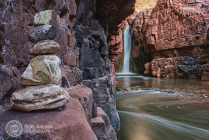
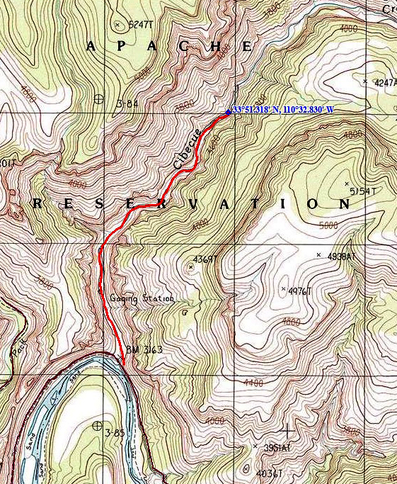
Flippin' Awesome! by joebartels  Spirit SpiritExcept for lack of challenge, few adventures compare to this one. You'll likely go home with a smile on your face. I must have been lucky. There wasn't another soul in the canyon. The weather was perfect, and so was the water. Trailhead There is no official trailhead. Just a ramada, a flipped over restroom, and a sign was telling you everything you can't do marks the start of this trail. I used "Canyoneering Arizona" to find this trail. The book says it's seven miles down the river road to Cibecue Creek. This is incorrect. It's only four. As there isn't any signage, it was a little confusing. So remember. When a creek crosses the road from a side canyon after four miles, that's the right area. Also, more importantly, the book mentions "swimming hole." According to the sign and special use permit, swimming is prohibited in all reservation waters.
Follow the creek upstream for 1.5 miles to the pounding waterfall. In the beginning, you can follow the left bank. It alternates back and forth too many times to count. The creek never got more than knee-high to the falls, with one exception. There is a wall-to-wall pool after midway. You can find a slip through the boulders on the left. Tons of river debris may make the narrow slot a challenge after big storms. The further you go, the better it gets. Clear blue-green pools get wider, and the canyon narrows. Tiny cascades and large boulders add to the experience. Be careful in the creek. Stepping out of the creek proved to be more slippery than in the creek. I saw only one fish on the entire trip. It was about four to five inches long and zipped right by me. It seemed like more than a mile of travel to the waterfall. Then again, the going is slow in and out of the creek. Every corner I kept thinking it must be coming soon. Then I realized it didn't matter as the scenery was fabulous. The last turn to the falls is almost worth the trip alone. The canyon bends back and forth. Clearwater pools look perfect. The canyon cuts into the walls, and it gets narrow. You can hear the pounding of the falls ahead. Okay, so swimming is not allowed, as mentioned above. So I won't go into that. Oh yeah, exploring beyond the falls is not permitted without a guide. It doesn't matter. The mile you're allowed to explore is fantastic. Anyhow have fun and be safe.
Check out the Official Route and Triplogs. Leave No Trace and +Add a Triplog after your canyon trip to support this local community. | ||||||||||||||||||||||||||||||||||||||||||||||||||||||||||||||||||||||||||||||||||||||||||||||||||||||||||||||||||||||||||||||||||||||||||||||||||||||||||||||||||||||||||||||||||||||||||||