Route Editor

| Guide | ♦ | 116 Triplogs | 8 Topics |
details | drive | no permit | forecast | 🔥 route |
stats |
photos | triplogs | topics | location |
| 1.3k | 116 | 8 |
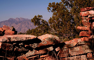
Mysterious & Spectacular by nealz   Overview OverviewThis guide is round-trip from Reavis Ranch. I suppose you could start at either the Reavis Ranch, Woodbury, Rogers Trough, or even Miles Ranch trailheads and make this a day hike but it would be a long and brutal day hike and I doubt you'd enjoy it as much. I've done this as a side trip during overnight stays at Reavis Ranch 'Base Camp' and like the luxury of the time, I can spend at the ruins. Circlestone is a remarkably well-preserved large circular ruin situated on top of a spectacular knoll at 6,010'. Just southeast of Circlestone is Mound Mountain, which at 6,266' is the highest point in the entire Superstitions. Some of the research done at Circlestone indicates it may be an ancient celestial 'calendar' not unlike Stonehenge in England. Before you go, I'd recommend a good short book that will give you a lot of background about the site - "Circlestone, A Superstition Mountain Mystery" by James A. Swanson and Thomas J. Kollenborn. It's small enough for inclusion in your backpack too and makes for a great read in the tent the night before you head up.
From your campsite at Reavis Ranch, get back on the Reavis Ranch Trail, FS #109, and follow it south past the old ranch house foundation and stock tank, across the meadow and down and across Reavis Creek. You will be on the east bank of Reavis Creek at this point. Continue south on FS #109 about 1/4 mile to the 'Y' of the Fireline Trail, FS #118. Head up the Fireline Trail away from the creek. I should mention that there will probably be no available water past this point so filter and fill up at the creek if you need to. The Fireline Trail travels up and out of the Reavis Creek drainage and quickly gets warmer and rockier - quite a change from the lush pines and grasses of Reavis Ranch. Continue on the Fireline Trail past Whiskey Spring about 2.25 miles, from the start of Fireline to a saddle. South of the Fireline is the bottom of the knoll that Circlestone sits on. The trail to Circlestone, which is sometimes called the Allen Blackman Trail, is not numbered or on the map. There is sometimes a cairn marking the trailhead on the south side of the Fireline Trail. The trail immediately starts up and begins to switchback through Manzanita and Gambel Oak. It can be a little loose in spots but is usually easy to follow. The forest opens up as you gain altitude and eventually the trail just straightens out and continues up the knoll at an easier grade to the ruin. The ruin is almost circular with some doors and lintel-topped windows still in place. The walls are somewhat tumbled down but in spots still, stand over 5 feet high. Stay off the walls and take care of this historical site. The views from here are great. In addition to Mound Mountain, you can see part of the mine at Miami to the east and the other peaks around Reavis Ranch to the west and northwest. Return the same way. There is another trail that starts at the saddle between Circlestone knoll and Mound Mountain and leads back down to the Reavis Trail, #109. It is extremely overgrown and steep in parts and your wayfinding skills will need to be sharp. My recommendation again is to go back down on the Fireline to Reavis Trail. Check out the Official Route and Triplogs. Leave No Trace and +Add a Triplog after your hike to support this local community. | ||||||||||||||||||||||||||||||||||||||||||||||||||||||||||||||||||||||||||||||||||||||||||||||||||||||||||||||||||||||||||||||||||||||||||||||||||||||||||||||||||||||||||||||||||||||||||||||||||||||||||||||||||||