
This multi-use Recreational Trail is restricted to non-motorized vehicles, and for the most part provides a great desert meander for mountain bike riders out of Las Cruces on the north end of the trail. Hiking seems a touch nicer when approached from the south end, Anthony Gap, walking slowly around and into the views of the Organ Mountains, first at a great distance, then as the day draws on, closer and closer. You never hike close or even into the foothills except when the initial crossing from the east side of the mountains over to the western side is traversed over a low pass. This is a desert wander. The first third is on winding jeep tracks, up and over various drainages, and unfortunately, along under high power lines. This 12-14 mile section is intersected by too many side road options, thus the 3 rating for route finding. You can either exercise lots of great luck or hike with someone who has done the route before, although the saving grace is to orient to the north/south high power lines; the trail is going where they are going. Unfortunately, depending on the recent weather, this section can include numerous sections of soft sand trudging. If there have been recent rains, consider yourself lucky and enjoy the packed track.
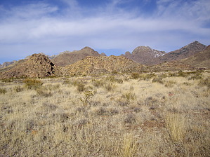
The next section is where the fun really begins. Shifting from jeep track to single track, now the desert characteristics get more interesting. Giant barrel cacti... lots of creosote... and the trails draws closer to some very interesting rock formations. The more dramatic of these, Pena Blanca, forms a focal point for a goodly bit of the hike. This portion of the trail is accessed and referred to as the Vado trailhead. This is a six or seven mile section.
The next section begins at the Mesquite trailhead, and the characteristics are much the same as the prior single track, with a bit more traipsing through a catclaw like hedge that would be impassable without a trail hacked through it. Rolling hills, spanish dagger forests, and ever closer mountain views make this a very nice trek. It is again six to seven miles before the North Trailhead at Soledad Canyon is reached.
The El Paso Ridgewalkers include this 28 mile hike as one of their annual event hikes.
This is mostly on BLM land (if I was told correctly) and there will be few people on the southern end, and possibly numerous bike riders as you draw closer to the northern end.
One-Way NoticeThis hike is listed as One-Way.
When hiking several trails on a single "hike", log it with a generic name that describes the hike. Then link the trails traveled, check out the
example.
 Route Editor


