 Route Editor

| Guide | ♦ | 150 Triplogs | 7 Topics |
details | drive | no permit | forecast | 🔥 route |
stats |
photos | triplogs | topics | location |
| 1.3k | 150 | 7 |
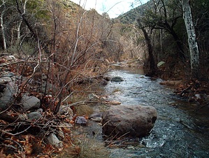
Enter Mazatzal by HAZ_Hikebot   2016 2016This trail has received a lot of maintenance since the Willow Fire in 2004. It's still difficult to follow in areas. Avid hikers will like it, and casual hikers will probably turn around. Hike Deer Creek Trail (#45) reminded me of both the Barnhardt trail (a few miles north) and Secret Mountain trail in Sedona. Barnhardt (BH) has well-paced and relatively uniform elevation gain (at least for my tastes) and provides an excellent sampling of all the Arizona terra zones (high desert scrub up to pines). Deer Creek (DC) starts similarly but has a much more modest elevation gain (at least for the first 4 miles or so.all the time I had that day). However, DC does have high desert, nice sections of riparian growth (cottonwood and sycamore trees, river grasses, ivy), a gurgling creek, gravesite (!), and a working windmill-powered water pump. I thought it was worth doing at least once.
I hiked on May 27, 2001 (Memorial weekend), and it wasn't a cool day by any means. Luckily there are sections of shade throughout (some pretty dense), and the trail more or less runs along the north side of a ridge/canyon, so going in, you've got ridge/shrub/trees rising to your left, creek to your right. I'd guess that in March/April, the sun is low enough in the sky that you're mostly in the shade once you're in the creek area. No other humans insight on this trail, half a dozen cottontails, a harmless water snake, and probably 1,000+ lizards. No deer! Like BH, it's got that funky mix of desert cactus type veg, mixed with high desert scrub, and oddly colored rock, deep purple, red, green, blue, etc. Prickly pear cactus was in bloom, as were a few blooms of some orange wildflower looking stuff near the creek. You're introduced to the creek after about 3/4 of a mile. Around this area, reach into your pack and pull out any horses you brought (ha ha) to give them a drink from the windmill-powered water pump that trickles water into a metal trough. From there, the trail alternates back and forth from being creekside to only being within earshot/view; brief sections of up/down over natural land contours. At the approx 1.5 to 2 mile mark, you'll find a single gravesite. 'David O. Cowan, 1843-1926'. At approx 3 1/4 miles, you 'officially' enter the Mazatzal Wilderness (a forestry sign tips you off). At this point, you're heading back creekside, actually crossing it several times (I think the full hike involves about 20 creek crossings after this point). The water level was maybe ankle-high, no big deal. The terrain was really getting interesting about this point but had to turn back. Eventually, it climbs into pine country. It's 8.8 miles one way to FR201 and numerous connecting trails. It would be worth returning after a good rain when everything is wet, and it's overcast for good photo opportunities. There were only some high diffuse clouds on my particular trip, so most pics ended up washed out. Check out the Official Route and Triplogs. Leave No Trace and +Add a Triplog after your hike to support this local community. One-Way Notice This hike is listed as One-Way. When hiking several trails on a single "hike", log it with a generic name that describes the hike. Then link the trails traveled, check out the example. | |||||||||||||||||||||||||||||||||||||||||||||||||||||||||||||||||||||||||||||||||||||||||||||||||||||||||||||||||||||||||||||||||||||||||||||||||||||||||||||||||||||||||||||||||||||||||||||||||||||||||||||||||||


