Route Editor

| Guide | ♦ | 8 Triplogs | 0 Topics |
details | drive | no permit | forecast | route |
stats |
photos | triplogs | topics | location |
| 80 | 8 | 0 |
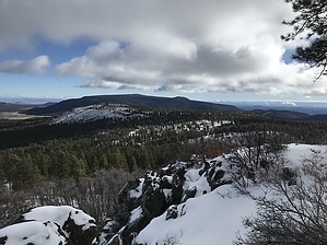
Logan's Walk by FOTG  Warning WarningRoad travel within the Grand Canyon Parashant National Monument is primitive. One must be entirely self-sufficient in terms of ability to change tires, self-recover, etc. Overview Mount Logan Wilderness is a small, (14,650 acres) one trail wilderness located within the Uinkaret Mountains of the Arizona Strip and the Grand Canyon Parashant National Monument.
Traditionally, indigenous groups of the area referred to the mountain as, "Yu-we-wu-guv," which translates to, "pines mountain" in Paiute. However, the more recognizable name of Mount Logan originated in 1869, after John Wesley Powell named the peak after a senator from Illinois. The Hike The Mount Logan Trail begins at a developed trailhead with parking and a sign-in register. There are no restrooms at the trailhead. The trail to the summit is approximately a half-mile and is marked with a trail sign and blazed trees. There are no water sources along the trail. Camping There are several opportunities for dispersed camping within Grand Canyon Parashant National Monument. Check out the Official Route and Triplogs. Leave No Trace and +Add a Triplog after your hike to support this local community. | ||||||||||||||||||||||||||||||||||||||||||||||||||||||||||||||||||||||||||||||||||||||||||||||||