The Maxwell Trail starts near the end of FR 81E at the northwest corner of the parking area. The trail switchbacks to the edge of the rim, then it's a steep descent into the canyon. Please be sure to stay on the trail in the section of the switchbacks as shortcutting destroys vegetation and aggravates erosion of the trail and surrounding ground cover.
The rocks exposed above the rim are predominately limestone laid down when a shallow sea covered the area. Once in the canyon, the rock type changes to sandstone deposited as sediment in an ancient ocean. The overstory vegetation along the trail consists of Transition Zone species of ponderosa pine, Douglas fir, and gambel oak. Native Americans utilized the acorns of the Gambel Oak as a food resource because of their high nutritive value.
As the trail nears the creek, the vegetation representative of a riparian community is encountered including red-osier dogwood, ash, willow, wild rose, canyon grape, box elder and poison ivy (learn to identify and avoid this three-leafed plant). The quiet pools characteristic of the creek provide habitat for blue gill, round-tailed chub, and suckers. This maintained trail ends at the creek but by bushwhacking and wading it is possible to access areas upstream and downstream of the trail.
When hiking several trails on a single "hike", log it with a generic name that describes the hike. Then link the trails traveled, check out the example.
WARNING! Hiking and outdoor related sports can be dangerous. Be responsible and prepare for the trip. Study the area you are entering and plan accordingly. Dress for the current and unexpected weather changes. Take plenty of water. Never go alone. Make an itinerary with your plan(s), route(s), destination(s) and expected return time. Give your itinerary to trusted family and/or friends.
Permit $$
None
Directions
Road
High Clearance possible when dry
To hike Location: Southeast of Flagstaff on roads that are either paved or graveled and suitable for passenger cars in most weather.
Access: From Happy Jack Ranger Station, follow Forest Highway 3 (Lake Mary Road) south for 7.5 miles to Forest Road (FR) 81. Go right (west) on FR 81 approximately 4 miles to the junction of FR 81 and FR 81E. Go left on FR 81E to the end of the road. High clearance vehicles are recommended, and the road may not be passable during wet weather.
From Clints Well (junction of State Route 87 and the FH-3), drive north on FH-3 approximately 7 miles to FR 81. Turn left (west) and proceed as above.
 Route Editor

 The Maxwell Trail starts near the end of FR 81E at the northwest corner of the parking area. The trail switchbacks to the edge of the rim, then it's a steep descent into the canyon. Please be sure to stay on the trail in the section of the switchbacks as shortcutting destroys vegetation and aggravates erosion of the trail and surrounding ground cover.
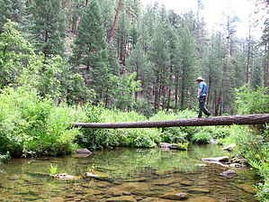


