If you only have time for a short hike on Mt Lemmon, this is a great trail. It's a pleasant, fairly easy hike from the Catalina Highway to the Marshall Gulch Picnic Area for a 3.2-mile roundtrip. You can experience the canyons, deep woods, and streams that contrast so sharply with the desert you left less than an hour before.
The trail winds through a shady, wooded area and then alongside a canyon that often has water making a trickling "waterfall" far below. It's possible to climb down to sit on the boulders near the water if you're more adventurous. Along the way, there are vistas into the canyon and toward Tucson. This area was only slightly burned during the fires on Mt Lemmon in 2002 and 2003, so the trail is one of the few that's attractive most of the way.
When the trail nears Marshall Gulch it becomes rocky and more uneven with big boulders and then drops steadily down into a forested creek bed. The trail crosses the creek (often dry) before reaching the parking lot at Marshall Gulch Picnic Area. There are some steep spots here, but there are several routes to try--some in the creek bed itself. The picnic grounds are in a deep forest with huge pines overhead, thus the ground is carpeted in needles. There are well-scattered concrete picnic tables and restrooms, but no water. It's a cool, shady spot to relax and enjoy being in the woods. Many birds and squirrels find the area attractive, so keep your eyes open, especially high in the trees.
To make a longer hike, head up the Aspen Trail to the left before you reach the parking area. After 2.5 miles the trail intersects with the Wilderness of Rocks, Mint Sprints, and Marshall Gulch Trails. Take Marshall Gulch Trail for 1.2 miles to return to the picnic area. Part of this loop goes through some of the heaviest burn areas, however. Return to your car on Sunset Trail. Total with this extended loop is 6.9 miles.
WARNING! Hiking and outdoor related sports can be dangerous. Be responsible and prepare for the trip. Study the area you are entering and plan accordingly. Dress for the current and unexpected weather changes. Take plenty of water. Never go alone. Make an itinerary with your plan(s), route(s), destination(s) and expected return time. Give your itinerary to trusted family and/or friends.
Four specific day-use areas require a Coronado Recreational Pass or a National Pass/America the Beautiful Pass.
1) Sabino Canyon - located on the Santa Catalina Ranger District (520)749-8700
2) Madera Canyon - located on the Nogales Ranger District (520)281-2296
3) Cave Creek - located on the Douglas Ranger District (520)364-3468
4) Mt. Lemmon at 11 day-use sites.
2025Catalina State Park
Per vehicle (1 person): $10.00
Per vehicle (2-4 people): $20.00
Individual/bicycle: $5.00
Coronado Forest MVUMs are rarely necessary to review unless mentioned in the description or directions Coronado Motor Vehicle Use Maps (MVUMs)
Directions
Road
Paved - Car Okay
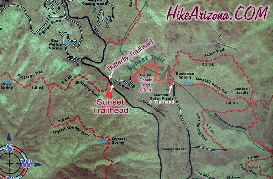
To hike HAZ: Take the Catalina Highway north off Tanque Verde Road in Tucson. Drive 4.2 miles to the Forest boundary and continue up Catalina Highway... I believe past mile marker 23. Be on the lookout for Butterfly Trailhead signs pointing to the right. Sunset Trailhead is maybe a hundred yards further on the left.
Red Rover: Catalina Highway from Tucson toward Mt Lemmon. Trailhead is marked on left near milepost 23. There's a small parking area and a marked trailhead.
 Route Editor

 If you only have time for a short hike on Mt Lemmon, this is a great trail. It's a pleasant, fairly easy hike from the Catalina Highway to the Marshall Gulch Picnic Area for a 3.2-mile roundtrip. You can experience the canyons, deep woods, and streams that contrast so sharply with the desert you left less than an hour before.
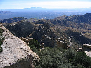


