 Route Editor

| Guide | ♦ | 90 Triplogs | 10 Topics |
details | drive | no permit | forecast | 🔥 route |
stats |
photos | triplogs | topics | location |
| 1.1k | 90 | 10 |
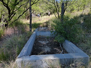
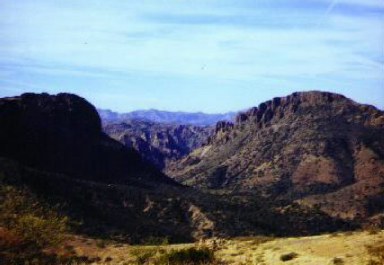
Scenic Shin Damage by Lizard  Prologue PrologueThe Frog Tanks Trail starts and ends in the middle of nowhere. It is not the easiest trail to access. However, it is a useful route because it connects Reavis Trail #109 with Roger's Canyon Trail #110. Hikers can use this trail to construct a great backpacking trip that takes in two of the coolest attractions in the Eastern Superstitions - Reavis Ranch and the Roger's Canyon cliff dwellings. Hike From the north, Frog Tanks Trail leaves trail 109 from a small open saddle. It heads to the west, paralleling the Paradise Creek drainage as it gradually loses elevation. This section of trail is an old roadbed and is easy to follow. After passing the cement trough at Plow Saddle Spring, which is often dry, it continues west hugging the side of the hills and contouring in and out of small drainages. This is my favorite section of the trail, as it traverses along open grassy mountainsides dotted with junipers. There are spectacular views of White Mountain and Fish Creek Canyon.
The trail eventually climbs to a small ridge above Fish Creek. This offers a respite from the catclaw, but do not get too excited. The trail on the ridge is thickly overgrown with prickly pear and agave. Agaves are sometimes called shin daggers, and if you don't know why, you will after hiking this trail! The overgrowth is so thick that you will sometimes have to leave the trail to pick your own course through the cacti, and you most likely will still come off this ridge with both of your legs bloody. The trail leaves the ridge and drops down to the confluence of Fish Creek Canyon and Roger's Canyon. There is a big pool of water here which is normally full. If it is not, you can turn left (east) and head up Fish Creek for about 50 yards. There are some pools of water here that are big enough to swim in. I saw a turtle in one of them, so they are most likely reliable. The remainder of the Frog Tanks Trail heads down Roger's Canyon, alternating from side to side. This canyon is very pretty, especially in the fall, and the route is well-cairned and easy to follow. `There is some catclaw, but nothing like the nightmare in Fish Creek. While I was hiking this canyon in November 1999, I came across a herd of about 10 coatimundi gathered around a boulder in the canyon bottom. Coatimundi seem to be easily spooked, as they scattered so fast I was left with only one blurry and indistinct photo. The Frog Tanks Trail ends at Angel Basin as it meets the Roger's Canyon Trail. Angel Basin, with its grassy clearings and towering canyon walls, is one of the best campsites in the Superstitions. Enjoy your hike! Check out the Official Route and Triplogs. Leave No Trace and +Add a Triplog after your hike to support this local community. One-Way Notice This hike is listed as One-Way. When hiking several trails on a single "hike", log it with a generic name that describes the hike. Then link the trails traveled, check out the example. | |||||||||||||||||||||||||||||||||||||||||||||||||||||||||||||||||||||||||||||||||||||||||||||||||||||||||||||||||||||||||||||||||||||||||||||||||||||||||||||||||||||||||||||||||||||||||||||||||||||||||||||||||||


