2026 March Changes
The Carney Spring Trailhead is closed. This hike now begins at the Lost Goldmine TH. It is 0.5 mile longer one-way and 16 feet less AEG.
Check out the Superstition Ridgeline for details on this hike.
If you're convinced the Flatiron is the most challenging out-n-back hike in the valley, this one might change your mind.
The Flatiron is roughly equivalent to 2 Squaw Peak or Camelback ascents. This bad boy is closer to 3 or a Humphries ascent.
flying_fliver excerpt
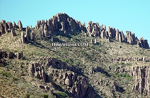
The original survey done on Peak 5057 is one of Arizona's oldest surveys (1899). Those original surveyors hiked up there with pack mules. I can't even imagine doing that hike with pack mules, especially going up Carney Springs. Obviously, we can only assume there was basically no trail for them to follow in 1899. They left the mules below the peak while they did their survey work.
In subsequent years (1910, 1936, 1938, and 1946), other surveyors put the various present 3 survey disks up there (& one carving in a boulder). The main disk is the one with the triangle on it, and the other 2 disks (Reference Marks) have arrows on them, pointing to the triangulation disk. The surveyors also carved that rudimentary "arrow" in a nearby boulder, pointing to the main disk. That carving was done in 1910 and also acted as a Reference Mark.
Next time you are up there, see if you can locate all 3 disks (easy) and the tiny arrow carving in the boulder. (not so easy)
WARNING! Hiking and outdoor related sports can be dangerous. Be responsible and prepare for the trip. Study the area you are entering and plan accordingly. Dress for the current and unexpected weather changes. Take plenty of water. Never go alone. Make an itinerary with your plan(s), route(s), destination(s) and expected return time. Give your itinerary to trusted family and/or friends.
Permit $$
None
Directions
Road
FR / Jeep Road - Car possible when dry
To Carney Spring Trailhead 7.6 miles east of the junction Idaho Rd / US-60. Turn Left on to FS77 which is Peralta Road. Follow FS77 5.6 miles to a left and up turnoff. Continue 0.6 miles to Carney Spring Trailhead.
Warning
This trailhead and the first 0.5 miles is periodically enforced as being on State Land, see permit for info.
2 easy ways to avoid the small lot and fee.
- Lost Goldmine TH / +0.9 miles GPS Route
- Peralta TH w/restrooms / +1.3 miles GPS Route
From PHX (I-10 & AZ-51) 46.3 mi - about 1 hour 6 mins From TUC (Jct 1-10 & Grant) 95.8 mi - about 2 hours 12 mins From FLG (Jct I-17 & I-40) 191 mi - about 3 hours 10 mins
 Route Editor

 2026 March Changes