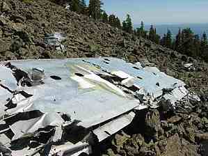
In the early morning hours of September 15th, 1944, a U.S. Army Air Force B-24 Bomber on a night training mission crashed into the San Francisco Peaks, killing all eight crewmen. This memorial is dedicated to those young American Airmen.
The Bomber still sits on the slopes of Humphreys Peak. From the Humphreys Trail Parking lot, if you look up the mountain, you will see a rock flow, and just above that, there is a small rocky clearing in the trees at about 11,000 feet. This is where they crashed, right in this clearing. From the Parking lot, you can look up there and see the sun glimmering off of the pieces of the plane.
Many have sought out this wreckage and have failed to find it. Looking for it is almost like finding a pin in a haystack, but it's not impossible to find. Here is a description to find it, but you must keep your eyes open, as, with directions, it's still hard to find. To find it, take the Humphreys trail about seven switchbacks up. Once you get to the rock field, cross over it and take it till it ends. From here, it's not really clear how to find it. You want to keep heading up the mountain while heading north. If you go too far north, not north enough, or angle too steep, you will miss it. Keep your eyes open for the propellers of the plane. Once you find pieces of it, head straight up, and you will enter a clearing in the trees, and there it is. This site is breathtaking, seeing how the plane tumbled up the mountain. It created gashes in the mountain, changing the landscape of the mountainside.
WARNING! Hiking and outdoor related sports can be dangerous. Be responsible and prepare for the trip. Study the area you are entering and plan accordingly. Dress for the current and unexpected weather changes. Take plenty of water. Never go alone. Make an itinerary with your plan(s), route(s), destination(s) and expected return time. Give your itinerary to trusted family and/or friends.
Permit $$
None
Directions
Road
Paved - Car Okay
To Humphries Trailhead From Flagstaff follow Highway 180 West 7 miles to FR516. Turn right onto FR516 (N. Snow Bowl Rd) and follow 6.2 miles to the first large signed parking lot on the left.
From PHX (I-10 & AZ-51) 164 mi - about 2 hours 41 mins From TUC (Jct 1-10 & Grant) 269 mi - about 4 hours 9 mins From FLG (Jct I-17 & I-40) 16.0 mi - about 31 mins
 Route Editor

 In the early morning hours of September 15th, 1944, a U.S. Army Air Force B-24 Bomber on a night training mission crashed into the San Francisco Peaks, killing all eight crewmen. This memorial is dedicated to those young American Airmen.