Hieroglyphics Trail #101 is an excellent trail for winter visitors, visitors from back east, or anyone looking for an easy, fun trail to hike in the beauty of the Superstition Mountains. Whenever I have out of town guest visiting, they always ask to see the desert. As a lifelong Arizona resident, I take these visitors on one of the first trails I ever hiked, the Hieroglyphics Trail in the Superstitions.
Hieroglyphics Trail #101 has changed over the many years in existence, and with the urban sprawl reaching the base of the Superstitions, it is sometimes difficult to find the old trailhead. There are some magnificent saguaros and picture-perfect photos ops of the superstitions along the way.
After about 25 minutes, you'll reach the official trailhead of the Hieroglyphics Trail. If the parking lot is full, please do not park illegally or on private property! The trail from this point climbs gradually through fields of saguaros, jumping cholla paloverde, creosote bush, and other desert plants. As the trail rises to Hieroglyphics Canyon, the end of your destination, teddy bear chollas join the cacti present along the trail. There are lovely views of Mesa and Apache Junction to the west, and wilderness is to the east. The trail levels out some and is a great place to stop and take in the desert beauty.
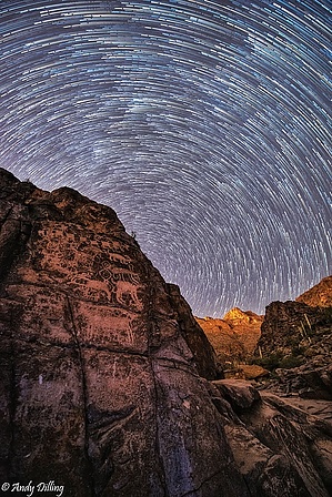
The trail continues and follows the drainage channel from the canyon. You will see spectacular views of the canyon ahead and rock formations along the way. After some minor rocks to climb over, you have reached the end of the trail and can view some remarkable Indian hieroglyphics. Beware, though, some of the hieroglyphics have been recently etched by modern-day morons. After rains, there will be pools of water in the rock areas. Every time I have been there when water was present, it was polluted. On the return trip, the views are just as great as the conversation about the hieroglyphics you've just seen. The total distance is about 1.8 miles from the official trailhead.
WARNING! Hiking and outdoor related sports can be dangerous. Be responsible and prepare for the trip. Study the area you are entering and plan accordingly. Dress for the current and unexpected weather changes. Take plenty of water. Never go alone. Make an itinerary with your plan(s), route(s), destination(s) and expected return time. Give your itinerary to trusted family and/or friends.
Permit $$
None
Directions
Road
Paved - Car Okay
To Hieroglyphics Trailhead From the East Valley follow US 60 East to South Kings Ranch Road. Kings Ranch Road is 14.1 miles east of Power Road for reference. Turn North on Kings Ranch Rd and follow to 2.8 miles to Baseline. Turn East on Baseline and follow 0.2 miles to Mohican. Turn North onto Mohican and follow 0.4 miles to Valleyview Road. Turn West onto Valleyview and follow (naturally turns North, and turns into Whitetail Road) for 1.4 miles. At the intersection of Whitetail Rd. and Cloudview Road turn East and follow 0.4 miles to the end. The trailhead parking is here and the trail is easy to spot to the East. If the parking lot is full, please do not park illegally or on private property!
From PHX (I-10 & AZ-51) 42.9 mi - about 54 mins From TUC (Jct 1-10 & Grant) 95.3 mi - about 2 hours 3 mins From FLG (Jct I-17 & I-40) 187 mi - about 2 hours 58 mins
 Route Editor

 Hieroglyphics Trail #101 is an excellent trail for winter visitors, visitors from back east, or anyone looking for an easy, fun trail to hike in the beauty of the Superstition Mountains. Whenever I have out of town guest visiting, they always ask to see the desert. As a lifelong Arizona resident, I take these visitors on one of the first trails I ever hiked, the Hieroglyphics Trail in the Superstitions.