Overview
Hikers originally accessed Thunder River,Tapeats Creek, and Deer Creek via the trail from Indian Hollow, but the Bill Hall Trail east of Monument Point offers a 2.5-mile shortcut and, as a result, has become the primary trailhead.
Hike
Pass through the gate at the end of FR 292A and follow the rim west toward Monument Point. As the trail rises toward the point watch for cairns marking the place the trail leaves the rim and enters the canyon. The trail drops steeply through the Kaibab and Toroweap Formations north of Bridgers Knoll, then contours northwest to the Coconino descent west of Monument Point.
Many switchbacks provide passage through the Coconino Sandstone and on to a small drainage leading down to the Esplanade and the junction with the Thunder River Trail from Indian Hollow. A short rope may be helpful to lower the packs at a short (15 feet) scramble.
Segments to Consider
Monument Point TH (7060 ft) to...
Gate Policy: If a gate is closed upon arrival, leave it closed after you go through. If it is open, leave it open. Leaving a closed gate open may put cattle in danger. Closing an open gate may cut them off from water. Please be respectful, leave gates as found. The exception is signage on the gate directing you otherwise.
When hiking several trails on a single "hike", log it with a generic name that describes the hike. Then link the trails traveled, check out the example.
WARNING! Hiking and outdoor related sports can be dangerous. Be responsible and prepare for the trip. Study the area you are entering and plan accordingly. Dress for the current and unexpected weather changes. Take plenty of water. Never go alone. Make an itinerary with your plan(s), route(s), destination(s) and expected return time. Give your itinerary to trusted family and/or friends.
To Monument Point Trailhead Jumping off point is Forest Road (FR) 22 located off of Highway 89A, just few miles east of the small town
of Fredonia, AZ. From FR 22 you will be turning onto FR 425. If you are heading to Indian Hollow and the
Thunder River trailhead, then turn onto FR 232 (this road ends at the trailhead). If you are heading for Bill
Hall trailhead, then continue further down FR 425 until you come to FR 292. FR 292 turns into FR 292A
and ends at the Bill Hall trailhead. Alternate access to FR 22 is from Demotte Park off of Highway 67.
During the winter and early spring deep snow and mud on the North Rim might close access roads and
cut off vehicle access to the trailheads.
From PHX (I-10 & AZ-51) 349 mi - about 7 hours 22 mins From TUC (Jct 1-10 & Grant) 454 mi - about 8 hours 52 mins From FLG (Jct I-17 & I-40) 203 mi - about 5 hours 14 mins
 Route Editor

 Overview
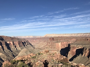


