Note
Stats are to the peak, including the Sunset Trail segment.
Overview
Between Phoenix and Tucson lies this mysterious peak jutting out of the desert. Picacho Peak is one of those mountains you just have to hike! This is a unique trail with cables and handrails placed by the Boy scouts long ago.
Hike
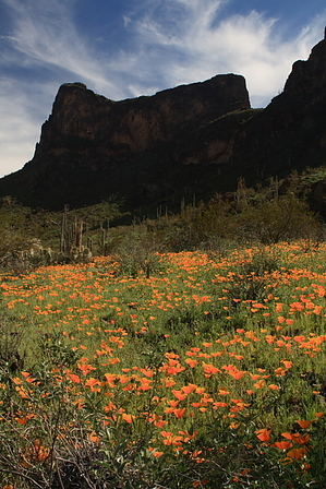
The first section takes you up steep switchbacks to the saddle. When in season, beautiful wildflowers are witnessed at the beginning of the trail. February through early April offers the best rewards. Keep an eye on triplogs and photosets.
Okay from the saddle you have just gained 968 feet in altitude. Now you will begin to descend believe it or not. Yes, descend almost half of what you just gained! ( 225 feet ) This is the beginning of the fun. Cables assist you down the steep slick slope. I would avoid this trail when it is wet! Some prefer gloves for the cables.
You merge onto the Sunset Trail. The trail goes back around the mountain and starts to ascend steeply near the end. Once again handrails, cables, and even bridges! assist you along the way. This is boy scout dreamland! At the peak enjoy the views. With a good knowledge of the surrounding area, this is a prime viewing location.
1-2 quarts of water is plenty for me in moderate weather. Pack a lunch for the summit. When a scattered group of fifty is chowing down you feel like it's the thing to do. Speaking from one that frequents the Valley shrines Piestewa and Camelback, this is similar terrain. It's just more intense with the cable grades. For the beginning hiker, I can only imagine this is quite a push. Stay out of 8 am-5 pm heat when hiking this area in the summer. Enjoy!
WARNING! Hiking and outdoor related sports can be dangerous. Be responsible and prepare for the trip. Study the area you are entering and plan accordingly. Dress for the current and unexpected weather changes. Take plenty of water. Never go alone. Make an itinerary with your plan(s), route(s), destination(s) and expected return time. Give your itinerary to trusted family and/or friends.
Permit $$
AZ State Parks more info
2026 Day Use Fees range from $5–$30
Per vehicle (1 person): $10.00
Per vehicle (2-4 people): $20.00
Individual/bicycle: $5.00
$200 Annual Pass
Directions
Road
Paved - Car Okay
To hike Between Phoenix and Tucson on Interstate 10 Exit 219. Follow the signs to Picacho State Park. Pay your dues and take a map.
 Route Editor

 Note
Note