Route Editor

| Guide | ♦ | 325 Triplogs | 1 Topic |
details | drive | permit | forecast | 🔥 route |
stats |
photos | triplogs | topic | location |
| 1.2k | 325 | 1 |
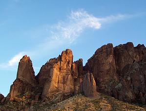
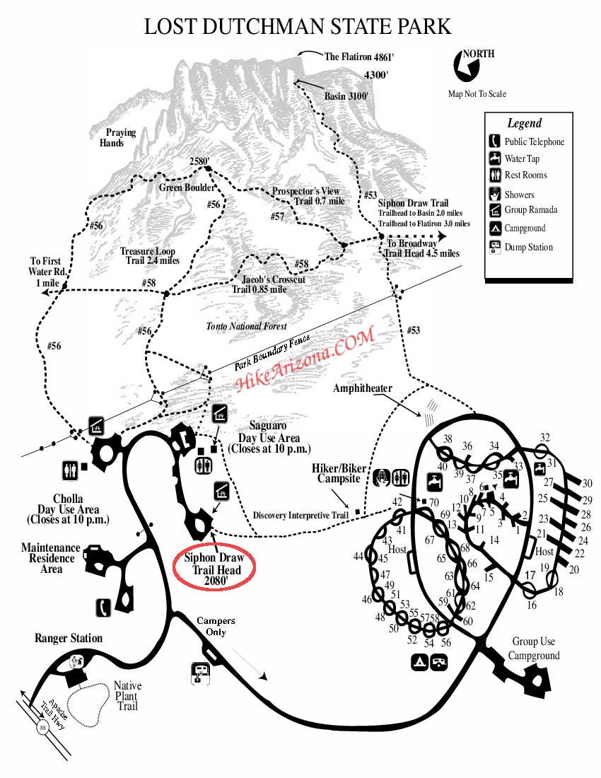
Scenic geologic stroll by tinyelvis   Named after the fabled lost gold mine, the Lost Dutchman State Park is located in the Sonoran Desert at an elevation of 2000 feet. The park offers a variety of hiking trails, nature trails, 35 regular campsites, picnic facilities, and special programs throughout the year. Named after the fabled lost gold mine, the Lost Dutchman State Park is located in the Sonoran Desert at an elevation of 2000 feet. The park offers a variety of hiking trails, nature trails, 35 regular campsites, picnic facilities, and special programs throughout the year.One of the more popular trails in the park is the Treasure Loop trail #56, a moderate 2.4 well-maintained loop exploring some of the mountain's more interesting geologic terrain. The trail can be accessed via the Cholla (northern side) Day-use Area or the Saguaro (southern) Day-use Area. For this trip, I began in the Cholla area.
The trail passes through a cattle guard and then continues along a fairly straight and low-grade path, climbing up the hill towards the bluffs. After a short distance, you will cross the intersection for Jacob's Trail #58. If you turn left (north) you will reach First Water Rd. in about 1 mile. NOTE: If you don't feel like paying the park fee, you can drive just past the Dutchman Park entrance and park on the right side of the road near First Water, and meet up with the Treasure Loop. Anyway, continue straight (east), heading further up the hill towards Praying Hands. You will notice Praying Hands directly in front of you, a common obstacle for rock climbers. Praying Hands is also a great side destination for hikers looking for more interesting geology and more of a physical challenge (see Treasure Loop to Praying Hands hike). If you are energetic, there are plenty of game trails that you can explore, leading further up into the bluff. These offshoots are very steep, rocky, and more difficult, but it's amazing how fast you can reach the mountain face via these routes. Progressing along the Loop, the trail levels out and passes above two large drainage channels that run down to the valley. Along the way you will pass Green Boulder, sitting at an altitude of 2580 feet. Eventually, you will reach the Prospectors Trail #57 intersection, a 0.7-mile segment that connects with the Broadway Trailhead and Siphon Draw Trail #53 (Flatiron). Also, look for a cairn slightly south of this intersection that will direct you towards a trail that will lead you up towards the bluff (look for the arch in the rock east of you). Continuing down the Treasure Loop you will encounter moderate switchbacks and you will eventually come across Jacob's Trail #58 again. Taking Jacob's Trail from here will lead you to Siphon Draw and the Broadway Trails. Shortly you will reach the Saguaro Day-use Area. To reach Cholla, take the dirt path to the right (north) and you're done. We reached Green Boulder in about 30 minutes, hiked up into one of the canyons towards the arch rock, and were back at the trailhead in a total time of 2 hours and 30 minutes. The best thing about this trail is that you can always extend or shorten your journey, tailoring it to as long or as short as you'd like.
Check out the Official Route and Triplogs. Leave No Trace and +Add a Triplog after your hike to support this local community. | |||||||||||||||||||||||||||||||||||||||||||||||||||||||||||||||||||||||||||||||||||||||||||||||||||||||||||||||||||||||||||||||