We did an out and back jaunt (page data is one-way for the official length of the trail) with astounding vegetation in the Superstitions even at the end of a summer season. This isn't the desert I always read about! The beauty out there is quiet and has the calm of rolling hills punctuated by sharp cliffs with strange spires. If you awoke here you would feel you were many miles into the wilderness.
The first part of the hike leaves Peralta on the Dutchman trail and climbs a small rise before dropping down into Barkley Basin. This part is fairly easy and winds along to the junction of the Dutchman and Coffee Flat. Here you veer right to cross Barkley Basin. Lots of ravines with ups and downs and a trail rockier and not as well defined as the Dutchman Trail #104. Easy to follow, however. You climb the south side of Barkley Basin and stop at the remains of an old wagon road that was used in the late 1800s from Mesa to Superior. We marveled at how rough that trip must have been. We continued to climb over a pass to drop into Whitlow Canyon before climbing another pass to drop into Coffee Flat proper.
The vegetation seems to get greener and lusher as you go. In Whitlow Canyon go south about 100 feet to the old corral. Try to visualize that activity in this wilderness. A rocky climb and sharp descent take you to the south end of Coffee Flat at Reeds Water in the shadow of Buzzard's Roost. Return the same route ending with the long climb out of Barkley Basin back to the lot.
This is a nice hike. Had we started at daybreak we might have tried to get to Dripping Springs but that RT of 13.5 miles might be a bit much for one day for me. Finally, again, I mention the lush trees and desert bushes and ground cover--even grass that we found. We did not find water but did find two old windmills at Reeds Water and doubtless much of the year there is water in the area.
When hiking several trails on a single "hike", log it with a generic name that describes the hike. Then link the trails traveled, check out the example.
WARNING! Hiking and outdoor related sports can be dangerous. Be responsible and prepare for the trip. Study the area you are entering and plan accordingly. Dress for the current and unexpected weather changes. Take plenty of water. Never go alone. Make an itinerary with your plan(s), route(s), destination(s) and expected return time. Give your itinerary to trusted family and/or friends.
Permit $$
no fees or permits reported
if incorrect tell us about it
Directions
Road
FR / Dirt Road / Gravel - Car Okay
To Peralta Trailhead 7.6 miles east of the junction Idaho Rd / US-60. Turn Left on to FS77 which is Peralta Road. Follow FS77 5.6 miles to a left and up turnoff. Continue 1.9 miles to Peralta Trailhead.
The trailhead has restrooms minus running water. The parking lot is enormous. It does fill up in season on weekends. Since there are no lines, the rangers ask that you park straight between the posts in the main lot. Please do your part with this simple request and make room for the next guy. 0.5 miles before reaching the trailhead is an overflow lot, which is also suited for horse trailer parking.
From PHX (Jct I-10 & AZ-51) 45.2 mi - about 1 hour 8 mins From TUC (Jct 1-10 & Grant) 97.0 mi - about 2 hours 16 mins From FLG (Jct I-17 & I-40) 192 mi - about 3 hours 15 mins
 Route Editor

 We did an out and back jaunt (page data is one-way for the official length of the trail) with astounding vegetation in the Superstitions even at the end of a summer season. This isn't the desert I always read about! The beauty out there is quiet and has the calm of rolling hills punctuated by sharp cliffs with strange spires. If you awoke here you would feel you were many miles into the wilderness.
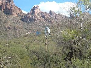


