Route Editor

| Guide | ♦ | 53 Triplogs | 2 Topics |
details | drive | permit | forecast | route |
stats |
photos | triplogs | topics | location |
| 560 | 53 | 2 |
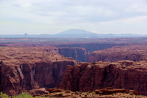
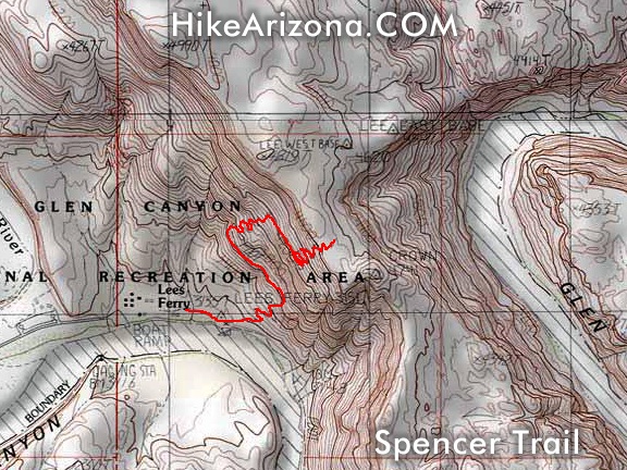
Climb Echo Cliff by Ben  This hike involves following the signs as one walks upstream. The trail divides as one path leads along the north side of the Colorado River, while the left branch heads up the Spencer Trail. After a hundred yards of a slight incline, the next mile is continual switchback climbing. During this climb, one can view the Echo Peaks to the south of the Colorado where John Dellenbaugh fired his pistol in 1872 in an attempt to use echo to determine distance from the peak to the river. The thousands of returning echoes lead him to just estimate elevation and name the 70-mile long cliff system the Echo Cliffs. Also, the Vermilion Cliffs with Powell's Monument on top are in full display. If an early morning hike is involved, the morning sun delivers the namesake colors. Also, the muddy waters of the Paria River can be seen entering the emerald green water of the Colorado. Below the painted desert colors of the Chinle Formation is also visible. After a considerable climb, Lee's Backbone, the early ferry road up the southern bank of the river, can be seen. This hike involves following the signs as one walks upstream. The trail divides as one path leads along the north side of the Colorado River, while the left branch heads up the Spencer Trail. After a hundred yards of a slight incline, the next mile is continual switchback climbing. During this climb, one can view the Echo Peaks to the south of the Colorado where John Dellenbaugh fired his pistol in 1872 in an attempt to use echo to determine distance from the peak to the river. The thousands of returning echoes lead him to just estimate elevation and name the 70-mile long cliff system the Echo Cliffs. Also, the Vermilion Cliffs with Powell's Monument on top are in full display. If an early morning hike is involved, the morning sun delivers the namesake colors. Also, the muddy waters of the Paria River can be seen entering the emerald green water of the Colorado. Below the painted desert colors of the Chinle Formation is also visible. After a considerable climb, Lee's Backbone, the early ferry road up the southern bank of the river, can be seen.Once the switchbacks end and the hiker reaches the top of the cliff, views of Page, Lake Powell, the Kaiparowits Plateau, The narrowing of Paria Canyon, and Navajo Mountain are available. After continuing another couple hundred yards, one can look 1,000 feet straight down into Glen Canyon. Walking along the Glen Canyon western rim is possible from downstream near Finger Arch and upstream to Death Pockets. If time permits, a hiker can continue north to Domingues Pass through the Echo Cliff. This is where the Spanish Fathers, Dominguez, and Escalante crossed in their return to trip south to the Hopi Mesas and eventually New Mexico.
Check out the Official Route and Triplogs. Note This is a moderately difficult hike. Leave No Trace and +Add a Triplog after your hike to support this local community. | |||||||||||||||||||||||||||||||||||||||||||||||||||||||||||||||||||||||||||||||||||||||||||||||||||||||||||||||||||||||||||||||||||||||||||||||||||||||||||||||||||||||||||||||||