 Route Editor

| Guide | ♦ | 100 Triplogs | 6 Topics |
details | drive | permit | forecast | route |
stats |
photos | triplogs | topics | location |
| 1.1k | 100 | 6 |
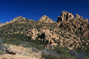
Salutory honk by fricknaley  The Dragoon Mountains in southeast Arizona are a great mid-altitude range and are pretty easy to get to. The Cochise Stronghold Trail is one of my favorites in this area. It's a nice combo of distance, difficulty (the elevation gain is only about 1100 feet - but you climb up the divide each way so double it up), and uniquely awesome scenery. It reminds me of Joshua Tree in some ways. Apparently, it's where Cochise often held up, and somewhere up in the mountains is where he's buried. The Dragoon Mountains in southeast Arizona are a great mid-altitude range and are pretty easy to get to. The Cochise Stronghold Trail is one of my favorites in this area. It's a nice combo of distance, difficulty (the elevation gain is only about 1100 feet - but you climb up the divide each way so double it up), and uniquely awesome scenery. It reminds me of Joshua Tree in some ways. Apparently, it's where Cochise often held up, and somewhere up in the mountains is where he's buried.Take off from the campground on the east side of the divide - there is also a western approach but it's 4-WD. There is a signed takeoff for the Cochise Trail. It actually begins from a short nature trail. Start by crossing a bridge and immediately coming to a fork (the nature trail is a loop). Take a quick left and follow for a couple of minutes to a sign pointing you off to the left again. Again follow for just a couple of minutes and a horse trail joins from your left and together (as the sign says) you take a right. Now you are off...
I recommend hiking down because the views down the western canyon are superior and the western side does have a bit of a different feel to it. It is steeper though. The hike down is straightforward as it switchbacks down the canyon. The views to your right are always tremendous. After about 1.75 miles you ultimately end back at ground level at the western trailhead - which looks to be pretty remote. Turn around and start your climb all over. The way back is tougher as you regain all the elevation in a little more than half the distance, but it's not that bad. The views are straight ahead the whole way and that's a pretty good incentive. Gate Policy: If a gate is closed upon arrival, leave it closed after you go through. If it is open, leave it open. Leaving a closed gate open may put cattle in danger. Closing an open gate may cut them off from water. Please be respectful, leave gates as found. The exception is signage on the gate directing you otherwise.
Coronado FS Details In the 1860's, the charismatic Chiricahua Apache leader, Cochise, adopted the rugged canyons that cross the midsection of the Dragoon Mountains as a refuge for himself and his people. The place came to be known as Cochise Stronghold. One feature of this natural fortress was that the two rocky canyons, one from each side of the mountain range, nearly meet high in the Dragoons. With their outlandish rock formations and thick oak-juniper vegetation they offer a concealed escape route in either direction. No one knows how many times Cochise and his people used these two canyons and the trail that connects them to move across these mountains. Today, Forest visitors travel this route as a portal back into this area's colorful past, as well as an access route to its scenic present. The trail extends between the Cochise Stronghold Campground on the east and a 4-wheel drive road (FR 688) into West Stronghold Canyon on the west side of the Dragoons. If you choose, you can travel all the way to Council Rocks at the mouth of West Stronghold. A trip along this trail will give you some idea why Cochise considered it a stronghold. Check out the Official Route and Triplogs. Leave No Trace and +Add a Triplog after your hike to support this local community. One-Way Notice This hike is listed as One-Way. When hiking several trails on a single "hike", log it with a generic name that describes the hike. Then link the trails traveled, check out the example. | ||||||||||||||||||||||||||||||||||||||||||||||||||||||||||||||||||||||||||||||||||||||||||||||||||||||||||||||||||||||||||||||||||||||||||||||||||||||||||||||||||||||||||||||||||||||||||||


