Route Editor

| Guide | ♦ | 69 Triplogs | 3 Topics |
details | drive | no permit | forecast | 🔥 route |
stats |
photos | triplogs | topics | location |
| 490 | 69 | 3 |
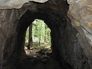
All Aboard the Historic Journey by joebartels   History HistoryLong ago a man named James W. Eddy had a dream to construct the Mineral Belt Railroad. The rail was to cross the state from North to South. Starting in Nogales and up through Globe, then up the rim passing through Flagstaff continuing up to the Utah border near Lees Ferry(the launching area for rafters into the Grand Canyon). In August 1883 work began on drilling a 3,100-foot tunnel to ascend the Mogollon Rim. 42 men labored all summer. After running low on funds twice the railroad was abandoned. Today the entrance to the railroad tunnel keeps the story alive. Overview Via North - 1.0 mi RT ( description below ) Via South - 3.5 mi RT
At the edge of the Rim is the trailhead. The trail goes straight down and the footing is loose. Sand and loose rock make the going tricky. Pass the second electric pole and cross the wash to your left. There is a small sign with a hiker about 50 feet AFTER you are on the correct trail. This junction is easy to miss. The wind takes advantage of the natural depression of the Rim. The day I hiked the trail seconds after leaving the Rim the wind kicked in. Once returning the second I stepped up on the Rim the wind ceased. The trail is steep heading down and curves to the junction with the Railroad Tunnel Trail. You have been following the Colonel Devin Trail #290 from the Rim and the Tunnel Trail is a spur trail that starts 0.37 miles down. From the rim, you have just dropped 380 feet. From the junction, it is just over a tenth of a mile up to the tunnel. The trail is steep in sections so please be careful. A dark black rock formation tricked my senses into believing I was near the Tunnel. Well, not much further over the tunnel came into view. What appears to be a recently constructed ruin is on the east side of the entrance. Upon first examining the tunnel, extensive graffiti is sad to see. Cool air inside makes the tunnel a great resting spot! The floor is fine-grain sand. Sit back and imagine the manpower it must have taken to drill it in the 1880s! Return to the trailhead. Enjoy the ride home through the dense Ponderosa Pines along the Rim. 10/03/08 - dshillis adds "The building next to the tunnel is the remains of a powder house."
Check out the Official Route and Triplogs. Leave No Trace and +Add a Triplog after your hike to support this local community. | |||||||||||||||||||||||||||||||||||||||||||||||||||||||||||||||||||||||||||||||||||||||||||||||||||||||||||||||||||||||||||||||||||||||||||||||||||||||||||||||||||||||||||||||||||||||||||||||||||||||||||||||||