Route Editor

| Guide | ♦ | 25 Triplogs | 3 Topics |
details | drive | permit | forecast | map |
stats |
photos | triplogs | topics | location |
| 279 | 25 | 3 |
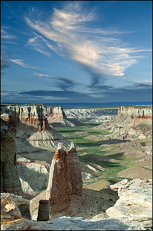
Bryce Spires on the Rez by Ben  Park near the lower (north) concrete tables of the Navajo Nation picnic ground. To the west, you can see the site of an old Mormon coal mine. Around the canyon walls, near the top, you will see a thin vein of soft coal. Other spots were mined too. Walk to the east to find the unmarked trailhead. Coal Mine Canyon is mostly on the Navajo Reservation. The trail starts to the east of the windmill and campground. About 150 feet west of a fence that goes over the edge, a faint trail leads down the north side of a mound can be found. Go around and more to the east, under the lower end of a fence. Then down the steep drainage toward the bottom, and into this picturesque canyon. Park near the lower (north) concrete tables of the Navajo Nation picnic ground. To the west, you can see the site of an old Mormon coal mine. Around the canyon walls, near the top, you will see a thin vein of soft coal. Other spots were mined too. Walk to the east to find the unmarked trailhead. Coal Mine Canyon is mostly on the Navajo Reservation. The trail starts to the east of the windmill and campground. About 150 feet west of a fence that goes over the edge, a faint trail leads down the north side of a mound can be found. Go around and more to the east, under the lower end of a fence. Then down the steep drainage toward the bottom, and into this picturesque canyon.As you continue down, drop bread crumbs so you will be able to identify the correct exit when you return. The canyon head has about five fingers and can surprise relaxed trekkers looking up at the Bryce-like scenes. If it has rained, expect to get dirty. Wear gloves as your hands will be used in the descent and return upward. Walk down the canyon to the northeast. After the decline, the hike is easy. About three miles in, you will be at the base of the 400 foot white and Red tower known as The Ghost. Along the way in and back, you should be able to see many arches and fantastic formations. Should you continue another mile or so, you will reach the opening of another beautiful canyon. Ha Ho No Geh Canyon is also magnificent.
Check out the Triplogs. Leave No Trace and +Add a Triplog after your hike to support this local community. | |||||||||||||||||||||||||||||||||||||||||||||||||||||||||||||||||||||||||||||||||||