Route Editor

| Guide | ♦ | 195 Triplogs | 16 Topics |
details | drive | no permit | forecast | 🔥 route |
stats |
photos | triplogs | topics | location |
| 1.8k | 195 | 16 |
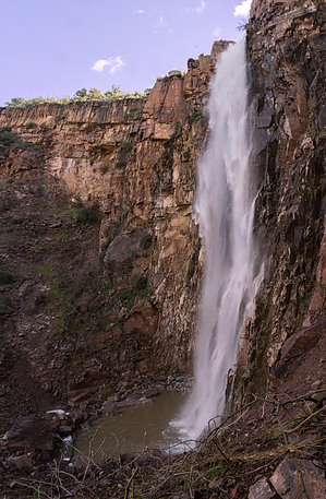
unexpected! by nealz   I'd been wanting to go back to Reavis Falls for some time but a lack of opportunities, combined with a dearth of water in the Superstitions, always seemed to put the kibosh on my plans. This time everything fell into place. I'd been wanting to go back to Reavis Falls for some time but a lack of opportunities, combined with a dearth of water in the Superstitions, always seemed to put the kibosh on my plans. This time everything fell into place.Most people would not believe you if you told them there is a 196-foot-tall waterfall (taller than Niagara) in the heart of the Superstition Mountains. The joke's on them, but here's the catch: the water volume of Reavis Creek, which supplies the falls, varies greatly depending on recent local rain or snowfall. Sometimes it's just a trickle. This time it was spectacular.
The trail starts down, then goes down again, and continues down some more. You can't help but think about the trip up later. About 1/2 mile down the trail, you pass a Sinagua ruin. There are plenty of potsherds but remember to leave 'em where you found 'em. Continue down and you will reach Lime Mountain Spring which runs right across the trail. Continue farther (down again) and you reach Reavis Creek. There are some cherry camping spots right along the creek but be aware that local wildlife needs access to the creek too. I saw plenty of deer tracks and sign at creekside. The plan now is to follow Reavis Creek up about a half-mile, to the falls. The trail starts and stops. Any way you find over boulders and under fallen trees that is semi-dry is fair. I've done this hike seven times now and I don't think I've hiked it the same way twice. Eventually, during one of your mandatory rest stops, you'll hear the muffled roar of the falls ahead and know that this isn't some cruel trick. There really is a waterfall down there. The falls are spectacular. They plummet over an escarpment and drop, pretty much unbroken, into a pool at your feet. There are ferns and mosses on the rock surrounding the pool and if it had been warmer, I might have gone for a swim. Spend as much time as you like at the falls but don't forget about the long hike up, It will take longer. Retrace your path back down the creek, up the trail to the saddle, which can be a little loose with scree in spots, then back down on the #109 to the trailhead. Leave your worries and sore feet behind but keep the memories. Check out the Official Route and Triplogs. Note This is a moderately difficult hike. Leave No Trace and +Add a Triplog after your hike to support this local community. | ||||||||||||||||||||||||||||||||||||||||||||||||||||||||||||||||||||||||||||||||||||||||||||||||||||||||||||||