Deadman Canyon Waterfalls Mazatzals

Find & Add Hiking Events!

Moderators: HAZ Group Coordinators, HAZ - Moderators

 Linked Guide  • Barnhardt Trail #43, AZ
Type Standard Hike, Climb, etc
 
Start Date 2009-03-28
 
# of days 1

User avatar
te_wa
Guides: 3 | Official Routes: 0
Triplogs Last: 1,667 d | RS: 2
Water Reports 1Y: 0 | Last: 1,867 d
Joined: Aug 22 2003 9:16 pm
City, State: Mesa

Deadman Canyon Waterfalls Mazatzals

Post by te_wa »

March 28-29th
This hike will start at the Barnhardt trailhead and follow 6 miles to the junction at Barnhardt Saddle. We stay straight (west) passing Chilson Spring on the Mazatzal Divide trail before dropping into an unnamed canyon that will lead us, offtrail, to the North Fork Deadman Canyon.
Once we slowly navigate into the bottom of this twisting, towering, remarkable canyon we head upstream to the "grand show". The waterfalls here at the head of this canyon are almost 250 feet tall. We will camp at the base of these falls, on the bedrock there are some flat spots. Nobody that I know of has ever camped here before. I searched the web for any info on this area and Todd mentions rappelling the falls from above. It is my understanding from pouring over the maps that the falls can (and will!) be reached from the bottom. However, there will be hell to pay.

I dont even know if the loop hike i plan to make is even possible, as it looks as if there is a 40-80 feet waterfall preventing travel on the second day of the loop. Retracing our steps back the way we came in is highly likely.

The first day is straightforward and includes 8 miles on trail, and about 2 offtrail.
day two might be much more demanding (but we'll get an early start) wherein we should have up to 4 miles of unknown territory to navigate and then another 7 miles of trail to travel.

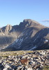
This is the Mazatzal range. Not for the timid. If you have not spent time here - this is not the time to make your first attempt! There is no other area I have hiked that is so demanding, requiring extreme navigation skills and hands-on canyoneering. Half the wilderness is burned. Even the trails shown on the maps are hard to follow. Please beware!

The HAZ wrecking crew should have no problem getting back home safely. Care to join me, you masochistic nuts? :scared:

the te-wa will fly
check out this pic of Deadman canyon from the top: http://hikearizona.com/phoZOOM.php?ZIP=60324
squirrel!
contribute to this member driven resource
ie: RS > Save/Share after hikes Route Scout GPS Topo Mapper on the App Store Route Scout GPS Topo Mapper on Google Play
User avatar
JoelHazelton
Guides: 16 | Official Routes: 1
Triplogs Last: 16 d | RS: 1
Water Reports 1Y: 2 | Last: 77 d
Joined: Mar 22 2006 7:45 am
City, State: Phoenix, AZ
Contact:

Re: Deadman Canyon Waterfalls Mazatzals

Post by JoelHazelton »

I'm excited to see tripologs and photosets next week.
"Arizona is the land of contrast... You can go from Minnesota to California in a matter of minutes, then have Mexican food that night." -Jack Dykinga

http://www.joelhazelton.com
contribute to this member driven resource
ie: RS > Save/Share after hikes Route Scout GPS Topo Mapper on the App Store Route Scout GPS Topo Mapper on Google Play
User avatar
rally_toad
Guides: 22 | Official Routes: 3
Triplogs Last: 829 d | RS: 60
Water Reports 1Y: 0 | Last: never
Joined: May 17 2007 8:06 pm
City, State: CA

Re: Deadman Canyon Waterfalls Mazatzals

Post by rally_toad »

Any news on the water in the area? Hopefully the falls are flowing since we're putting some effort in to get to the bottom of them.
"Who are you guys??!!" -Farnsworth
contribute to this member driven resource
ie: RS > Save/Share after hikes Route Scout GPS Topo Mapper on the App Store Route Scout GPS Topo Mapper on Google Play
User avatar
te_wa
Guides: 3 | Official Routes: 0
Triplogs Last: 1,667 d | RS: 2
Water Reports 1Y: 0 | Last: 1,867 d
Joined: Aug 22 2003 9:16 pm
City, State: Mesa

Re: Deadman Canyon Waterfalls Mazatzals

Post by te_wa »

water reported last week in the drainage from Windsor saddle, which is normally dry. The falls are usually just a light shower anyway, but should be a decent ~1-2 gallon per second flow. There is pro'lly still mucho underground water from snowmelt.

and even if there is just a trickle, the canyon is neat even when dry. Ive been in August and there was a nice flow.
squirrel!
contribute to this member driven resource
ie: RS > Save/Share after hikes Route Scout GPS Topo Mapper on the App Store Route Scout GPS Topo Mapper on Google Play
User avatar
deserttarheel
Triplogs Last: 1,002 d | RS: 0
Water Reports 1Y: 0 | Last: never
Joined: Oct 25 2003 4:31 pm
City, State: Phoenix, AZ
Contact:

Re: Deadman Canyon Waterfalls Mazatzals

Post by deserttarheel »

Unfortunately, my wife has "other plans" for us this w/e so I can't go. I have a score to settle w/ the western Mad-as-Hells, so sometime I would love to hike some of the trails that start at the Verde with you.

BTW, Te-Wa, let me know when you want to hike the Chiricahuas if you want a (slow-ish but getting better) partner.
Molon Labe ("Come and get them.")
contribute to this member driven resource
ie: RS > Save/Share after hikes Route Scout GPS Topo Mapper on the App Store Route Scout GPS Topo Mapper on Google Play
User avatar
te_wa
Guides: 3 | Official Routes: 0
Triplogs Last: 1,667 d | RS: 2
Water Reports 1Y: 0 | Last: 1,867 d
Joined: Aug 22 2003 9:16 pm
City, State: Mesa

Re: Deadman Canyon Waterfalls Mazatzals

Post by te_wa »

Steve, Chiricahua Crest in June. Keep ears peeled. ;)
squirrel!
contribute to this member driven resource
ie: RS > Save/Share after hikes Route Scout GPS Topo Mapper on the App Store Route Scout GPS Topo Mapper on Google Play
User avatar
Sredfield
Guides: 4 | Official Routes: 4
Triplogs Last: 50 d | RS: 0
Water Reports 1Y: 0 | Last: 504 d
Joined: Sep 08 2002 1:07 pm
City, State: Ahwatukee, AZ

Re: Deadman Canyon Waterfalls Mazatzals

Post by Sredfield »

rally_toad wrote:Any news on the water in the area? Hopefully the falls are flowing since we're putting some effort in to get to the bottom of them.
As of 3/28/09 there was a moderate flow at Horse Camp Seep, which I believe goes over the falls, also, still some flow at the very north end of Deadman Creek. Most major drainages north of Chilson had flows.
Shawn
The bear went over the mountain to see what he could see.
contribute to this member driven resource
ie: RS > Save/Share after hikes Route Scout GPS Topo Mapper on the App Store Route Scout GPS Topo Mapper on Google Play
Post Reply

Return to “Hiking Events”