 Route Editor

http://hikearizona.com/photoset.php?ID=11500INCIDENT UPDATED 40 MIN. AGO
Incident Overview
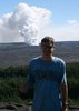
The Schultz Fire was reported at approximately 11:00 Sunday morning, and is located in the Schultz Pass area on the southeast side of the San Francisco Peaks. Crews are faced with hot, dry weather and high winds. As of 6:00 pm Forest officials believe the fire is approximately 5000 acres. Approximately 300 firefighters are on scene, additional fire resources are en route. Currently there are 8 air tankers and 5 helicopters assigned. The Southwest Type 1 Incident Management Team, Dugger Hughes Incident Commander, is en route and scheduled to assume management of the fire Monday, June 21 at 6:00 am.
Evacuations: Wupatki Trails subdivision; Timberline Estates subdivision, Sunset Crater National Monument; Second Chance Animal Shelter (animals safely evacuated to Fort Tuthill County Park); and there is no mandatory evacuation of Fernwood subdivision, although some residents have left.
Closures: State Highway 89 is closed from MP 433 (2.5 miles north of Sunset Crater National Monument) to Silver Saddle Road.
Basic Information
Incident Type Wildfire
Cause Unknown
Current Situation
Size 5,000 acres
Fuels Involved
Ponderosa pine, mixed conifer and pinyon-juniper
Fire Behavior
Very high rates of spread and high intensities observed. Spotting up to 1/2 mile.
Unit Information
USFS Shield
Coconino National Forest
U.S. Forest Service
1824 S. Thompson St.
Flagstaff, AZ 86001
Incident Contact
Emergency Operations Center
Phone: 888-679-8393
Follow this Incident
* Twitter Feed
* Article RSS Feed
* Google Earth Network Feed
help »
Share This
* Digg
* Del.icio.us
Schultz Fire on the San Francisco Peaks
Moderator: HAZ - Moderators
Linked Area, etc none
-
 JimGuides: 76 | Official Routes: 39Triplogs Last: 33 d | RS: 93Water Reports 1Y: 6 | Last: 45 d
 - Joined: Sep 08 2006 8:14 pm
Schultz Fire on the San Francisco Peaks
http://www.inciweb.org/incident/1996/
contribute to this member driven resource
ie: RS > Save/Share after hikes 

-
JimGuides: 76 | Official Routes: 39Triplogs Last: 33 d | RS: 93Water Reports 1Y: 6 | Last: 45 d
- Joined: Sep 08 2006 8:14 pm
Re: Schultz Fire on the San Francisco Peaks
I'm loading video of the fire I shot while on the lower flank of Humphrey today as I approached the Cirque. Could people see this from other parts of the state? I saw a photo from Sedona that makes it look like it was in Sedona.
Youtube # 1
https://www.youtube.com/watch?v=kc4Jz06Ufbo
#2
https://www.youtube.com/watch?v=TMMvF4XZi2g
Youtube # 1
https://www.youtube.com/watch?v=kc4Jz06Ufbo
#2
https://www.youtube.com/watch?v=TMMvF4XZi2g
contribute to this member driven resource
ie: RS > Save/Share after hikes
-
 JimmyLydingGuides: 111 | Official Routes: 94Triplogs Last: 768 d | RS: 0Water Reports 1Y: 0 | Last: 2,340 d
 - Joined: Feb 16 2007 3:17 pm
- City, State: Walnut Creek, CA
Re: Schultz Fire on the San Francisco Peaks
We could see a lot of smoke coming from the Flagstaff area as we were coming south on SR 87 above Strawberry, but never had a good chance to check it out from a good viewpoint.
contribute to this member driven resource
ie: RS > Save/Share after hikes
-
JimmyLydingGuides: 111 | Official Routes: 94Triplogs Last: 768 d | RS: 0Water Reports 1Y: 0 | Last: 2,340 d
- Joined: Feb 16 2007 3:17 pm
- City, State: Walnut Creek, CA
Re: Schultz Fire on the San Francisco Peaks
I guess next week would be a bad time to do the Weatherford-Kachina loop.... Bummer because that WAS one of the possibilities
contribute to this member driven resource
ie: RS > Save/Share after hikes
-
JimGuides: 76 | Official Routes: 39Triplogs Last: 33 d | RS: 93Water Reports 1Y: 6 | Last: 45 d
- Joined: Sep 08 2006 8:14 pm
Re: Schultz Fire on the San Francisco Peaks
Yeah, don't expect to have access to that area until autumn, at the earliest. I actually expect a forest closure tomorrow.Jim Lyding wrote:I guess next week would be a bad time to do the Weatherford-Kachina loop.... Bummer because that WAS one of the possibilities
contribute to this member driven resource
ie: RS > Save/Share after hikes
-
JimmyLydingGuides: 111 | Official Routes: 94Triplogs Last: 768 d | RS: 0Water Reports 1Y: 0 | Last: 2,340 d
- Joined: Feb 16 2007 3:17 pm
- City, State: Walnut Creek, CA
Re: Schultz Fire on the San Francisco Peaks
Perhaps Kendrick will be cool by next Sunday. Either that or I'll have to drag my mom to the Pinals, and I don't even want to think about the ramifications of that!
contribute to this member driven resource
ie: RS > Save/Share after hikes
-
JimGuides: 76 | Official Routes: 39Triplogs Last: 33 d | RS: 93Water Reports 1Y: 6 | Last: 45 d
- Joined: Sep 08 2006 8:14 pm
Re: Schultz Fire on the San Francisco Peaks
The Eagle Rock Fire ought to be out by then.Jim Lyding wrote:Perhaps Kendrick will be cool by next Sunday. Either that or I'll have to drag my mom to the Pinals, and I don't even want to think about the ramifications of that!
contribute to this member driven resource
ie: RS > Save/Share after hikes
-
JimGuides: 76 | Official Routes: 39Triplogs Last: 33 d | RS: 93Water Reports 1Y: 6 | Last: 45 d
- Joined: Sep 08 2006 8:14 pm
Re: Schultz Fire on the San Francisco Peaks
I just saw a photo on the AZ Dailsun website that shows the fire did not burn up the west side of Schultz Peak. I hope this is the case and that the fire is not climbing the south face of the Peaks as I originally thought.
contribute to this member driven resource
ie: RS > Save/Share after hikes
-
 hippiepunkpirateGuides: 25 | Official Routes: 23Triplogs Last: 501 d | RS: 0Water Reports 1Y: 0 | Last: 3,874 d
 - Joined: May 30 2008 7:43 am
- City, State: Peoria, AZ
- Contact:
Re: Schultz Fire on the San Francisco Peaks
My parents could see the smoke cloud from near Zion National Park in Utah  . I also expect a forest closure tomorrow, but do you really think until autumn, Jim?
contribute to this member driven resource
ie: RS > Save/Share after hikes
-
JimGuides: 76 | Official Routes: 39Triplogs Last: 33 d | RS: 93Water Reports 1Y: 6 | Last: 45 d
- Joined: Sep 08 2006 8:14 pm
Re: Schultz Fire on the San Francisco Peaks
No, not now. When I wrote that 15 minutes ago or so I was working with my assumption that I had all day, and that was the fire had started west of Schultz pass and headed very quickly up Schultz Peak. Had that been the case there would have been an area closure to allow the forest to regrow during monsoon season. They almost always seem to open up areas to hunting in the fall. However, the photo from 39,000' feet shows that the fire blew through the pass and appears to have burned the Weatherford Trail/ Schultz Peak area very little. Good news for us.hippiepunkpirate wrote:My parents could see the smoke cloud from near Zion National Park in Utah
http://www.azdailysun.com/news/local/ar ... 03286.html
contribute to this member driven resource
ie: RS > Save/Share after hikes
-
hippiepunkpirateGuides: 25 | Official Routes: 23Triplogs Last: 501 d | RS: 0Water Reports 1Y: 0 | Last: 3,874 d
- Joined: May 30 2008 7:43 am
- City, State: Peoria, AZ
- Contact:
contribute to this member driven resource
ie: RS > Save/Share after hikes
-
JimGuides: 76 | Official Routes: 39Triplogs Last: 33 d | RS: 93Water Reports 1Y: 6 | Last: 45 d
- Joined: Sep 08 2006 8:14 pm
Re: Schultz Fire on the San Francisco Peaks
Wow, that got all the way to Silverton, CO before the sun set.
contribute to this member driven resource
ie: RS > Save/Share after hikes
-
 azbackpackrGuides: 34 | Official Routes: 30Triplogs Last: 36 d | RS: 0Water Reports 1Y: 8 | Last: 46 d
 - Joined: Jan 21 2006 6:46 am
- City, State: Eagar AZ
Re: Schultz Fire on the San Francisco Peaks
Who needs CNN? I just tune into HAZ! 
My daughter called after driving back to her home in Flag. She said from her house, right by the historic district in Flag the fire glow on the mtn. is very bright orange. She also remarked on the sunset she viewed as she drove west on I-40.
My daughter called after driving back to her home in Flag. She said from her house, right by the historic district in Flag the fire glow on the mtn. is very bright orange. She also remarked on the sunset she viewed as she drove west on I-40.
There is a point of no return unremarked at the time in most lives. Graham Greene The Comedians
A clean house is a sign of a misspent life.
A clean house is a sign of a misspent life.
contribute to this member driven resource
ie: RS > Save/Share after hikes
-
 paulhubbardGuides: 8 | Official Routes: 1Triplogs Last: 166 d | RS: 0Water Reports 1Y: 0 | Last: 4,400 d
 - Joined: Jun 01 2010 9:54 am
- City, State: Mesa, AZ
- Contact:
Re: Schultz Fire on the San Francisco Peaks
Reminds me of the Eldon fire... Had to be human caused, there were no storms Sunday. I was downtown and saw the cloud grow - what a shame.
Good judgement comes from experience. Experience comes from bad judgement.
contribute to this member driven resource
ie: RS > Save/Share after hikes
-
 hikeazGuides: 6 | Official Routes: 0Triplogs Last: 1,239 d | RS: 0Water Reports 1Y: 0 | Last: 1,239 d
 - Joined: May 13 2002 10:07 am
- City, State: Tempe, AZ
- Contact:
Re: Schultz Fire on the San Francisco Peaks
We were camped at Schultz Pass Friday & Saturday nights, hiking to the summit via Weatherford on Saturday and over on the Sunset Trail side on Sunday. When the fire first broke out it appeared as if it was just a small dust devil. (Yeah, i know, all fires start small). We were at the Schultz Pass T/H as the fire personel arrived. Shortly, the air crane was sucking water from Schultz Tank about once a minute. (I suppose that the silver lining is that Schultz Tank was so close to the fire and supplied all the water they could use, although it doesn't seem to have slowed the fire down much).
The fire started just NE (by a few feet) of Schultz Tank and jumped Schultz Tank Road within a few minutes, heading northeast. There were no storms, so my supposition is that it was started by an unattended campfire.
I hear that they arrested someone for the Little America fire and I hope that they find who is responsible for the Schultz fire, but regardless, the forest will never be the same - the damage is done. I can see the temptation for the NFS to institute campfire bans in all forests because of the almost instantaneous destruction if one gets out of control, but it's really stupid people who cause fires, not campfires.
"The censorship method ... is that of handing the job over to some frail and erring mortal man, and making him omnipotent on the assumption that his official status will make him infallible and omniscient."
George Bernard Shaw
George Bernard Shaw
contribute to this member driven resource
ie: RS > Save/Share after hikes
-
 fricknaleyGuides: 93 | Official Routes: 59Triplogs Last: 5 d | RS: 6Water Reports 1Y: 3 | Last: 186 d
 - Joined: Jun 20 2003 4:07 pm
- City, State: Tucson, AZ
contribute to this member driven resource
ie: RS > Save/Share after hikes
-
hikeazGuides: 6 | Official Routes: 0Triplogs Last: 1,239 d | RS: 0Water Reports 1Y: 0 | Last: 1,239 d
- Joined: May 13 2002 10:07 am
- City, State: Tempe, AZ
- Contact:
Re: Schultz Fire on the San Francisco Peaks
Best I could tell, the fire stayed east of the lower portions of the Weatherford, but with all the smoke and no good visible landmarks, it was tough to say.fricknaley wrote:@hikeaz
did the weatherford trail burn?
Thinking that it may be consumed, we commented to each other that we may end up being the last folks to hike it pre-fire. Let's hope not. Let's pray that it was untouched.
"The censorship method ... is that of handing the job over to some frail and erring mortal man, and making him omnipotent on the assumption that his official status will make him infallible and omniscient."
George Bernard Shaw
George Bernard Shaw
contribute to this member driven resource
ie: RS > Save/Share after hikes
-
 joebartelsGuides: 264 | Official Routes: 224Triplogs Last: 3 d | RS: 2064Water Reports 1Y: 28 | Last: 13 d
 - Joined: Nov 20 1996 12:00 pm
Re: Schultz Fire on the San Francisco Peaks
amen, the sad part is effective prevention measures are being ignored toohikeaz wrote:it's really stupid people who cause fires, not campfires
Apparently Kendrick's lookout is volunteer and no one volunteered this year. The Eagle Rock Fire would have been an easy spot...
Do hope the Elden lookout is/was manned this year.
- joe
contribute to this member driven resource
ie: RS > Save/Share after hikes
-
hikeazGuides: 6 | Official Routes: 0Triplogs Last: 1,239 d | RS: 0Water Reports 1Y: 0 | Last: 1,239 d
- Joined: May 13 2002 10:07 am
- City, State: Tempe, AZ
- Contact:
Re: Schultz Fire on the San Francisco Peaks
When I was @ Kendrick 2-3 weeks ago it was manned. I heard from the volunteer there that Coconino NF is looking for additional fire-spotters. I posted the info on how to volunteer on an earlier post in another thread somewhere.
The Schultz fire was spotted by Elden L.O.
The Schultz fire was spotted by Elden L.O.
"The censorship method ... is that of handing the job over to some frail and erring mortal man, and making him omnipotent on the assumption that his official status will make him infallible and omniscient."
George Bernard Shaw
George Bernard Shaw
contribute to this member driven resource
ie: RS > Save/Share after hikes
-
hippiepunkpirateGuides: 25 | Official Routes: 23Triplogs Last: 501 d | RS: 0Water Reports 1Y: 0 | Last: 3,874 d
- Joined: May 30 2008 7:43 am
- City, State: Peoria, AZ
- Contact:
Re: Schultz Fire on the San Francisco Peaks
The Elden L.O. has been manned the last couple years by some paranoid nutjob.
contribute to this member driven resource
ie: RS > Save/Share after hikes