History
This trail is a little known or hiked trail, the one thing that made it interesting to me was that the Gowan property is located on this trail and not on the Deer Creek trail. David Gowan was one of the first pioneers in this region, he had a claim on the Verde River just west of the town of Payson. He was also credited for discovering the Tonto Natural Bridge, the story goes like this, he was hunting in the Pine Creek area when a group of Indians chased him up the creek where he took cover under the bridge. Which he later gave the property to his relatives, the Goodfellows. A good book I've found for information is Rim Country History put out by the Gila County Historical Society
Hike
This hike starts at the Deer creek trailhead, you start on the Deer Creek Trail #45 but within the first quarter-mile you run into first the Gold ridge trail #47, and very shortly after that you come to the South Fork Trail #46 intersection, The trail is nice for the first few miles until it turns south and starts heading up the south fork of Deer Creek, where it's rock hopping for the next few miles, 3 1/4 miles you come into the Mazatzal wilderness for about a mile and a half then back out, about 1/2 mile from the wilderness boundary you come to the Gowan property.
When you reach the Gowan property you're about a half-mile from the end of the trail at Pigeon Springs on the FR201. A major storm last January 2010 has changed all the trails in this area with fallen trees etc, like all other trails in this area I saw many signs of fresh bear droppings so take extra measures (making a lot of noise) I've personally run into several bears in the Mazatzal Mountains but have always avoided contact.
When hiking several trails on a single "hike", log it with a generic name that describes the hike. Then link the trails traveled, check out the example.
WARNING! Hiking and outdoor related sports can be dangerous. Be responsible and prepare for the trip. Study the area you are entering and plan accordingly. Dress for the current and unexpected weather changes. Take plenty of water. Never go alone. Make an itinerary with your plan(s), route(s), destination(s) and expected return time. Give your itinerary to trusted family and/or friends.
Permit $$
None
Directions
Road
Paved - Car Okay
To hike Head North from Phoenix on Hwy 87 to milepost 235 at the intersection of HWY 87 / HWY 188 turn left into the Deer Creek Trailhead parking area and let the fun begin.
 Route Editor


 History
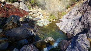


